• Skip to main content
  • Skip to secondary menu
  • Skip to primary sidebar
  • Skip to secondary sidebar
  • Skip to footer
  • DroneRacingLife
  • DroneFlyers
  • Newsletter
DroneLife

DRONELIFE

Stay up to date on all the latest Drone News

  • News
  • Products
  • Industries
    • Agriculture
    • Construction
    • Delivery
    • Dual Use
    • Inspection
    • Public Safety
    • Surveying
  • Enthusiasts
  • Regulations
  • Business
  • Video
  • Podcasts

Pix4D Introduces New Products, New Innovations Designed for Real Work

October 2, 2019 by Miriam McNabb 4 Comments

One of the best aspects of user conferences is getting a sneak peek at new products.  At Pix4D’s User Conference in Denver today, the company introduced two soon-to-be-released offerings: Pix4Dsurvey and Pix4Dreact.
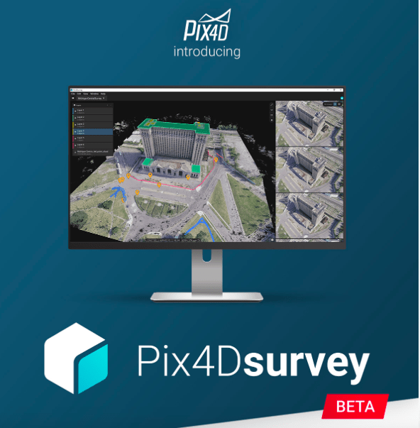
Pix4Dsurvey

Product manager Nate Moore offered an overview of Pix4Dsurvey, a tool that bridges the gap between photogrammetry and computer aided design and drafting (CAD) tools.

CAD tools replace manual drafting – and they are used extensively in engineering and construction projects.  Photogrammetry and 3D models are growing in importance in the industry: but Moore explains that after acquiring drone data and processing, removing noise and getting the data into CAD tools can represent a big investment in time and manual effort.  “It’s not uncommon to hear of people who spend one morning flying and three days removing noise and doing everything else that needs to be done,” explains Moore.

Pix4Dsurvey is designed to reduce those three days, smoothing the workflow for digital surveyors and engineers.  “We see this as a next step in Pix 4D photogrammetry workflows,” says Moore.

Pix4Dsurvey is a standalone product, and allows users to take data from multiple sources including Pix4Dmapper.  The product is designed to provide seamless merging of photogrammetry point clouds and images, LiDAR and third part point clouds in a single product.  It helps users optimize vectorization and extraction of essential information, such as bottom of top of curbs and catenaries.  In closed beta now, Pix4D expects to release Pix4Dsurvey in early 2020.

Pix4Dreact

We wrote last week about Pix4Dreact (also in beta, but soon to be released), when Technical Sales Engineer Angad Singh introduced the product at DJI’s Airworks conference.  The product produces very, very fast generation of 2D maps, ideal for emergency services applications like fire and police.

Singh has been out in the field with emergency services personnel for months, introducing the product – and he is clearly enthusiastic. “It’s pretty cool to show people a tool that they can actually use,” he says. “In an emergency, information saves lives.  I genuinely believe that this will make a big impact.”

Pix4Dreact is designed for the practicalities of life in the field for emergency services personnel.  They’re often using computers that are underpowered and several years old.  They may be working in areas without any internet connection.  They don’t have time to learn a complicated software.  And they don’t have a lot of budget to spend.

The room applauded when Singh demonstrated the product, generating an accurate 2D map in about 48 seconds – and with 4 simple steps.  This is a product that will protect environments and personnel: and most importantly, it’s realistic and accessible. “Pix4Dreact is designed for mass proliferation of this technology,” says Singh.

Based on reaction from attendees at the conference, Pix4Dreact is a win for Pix4D: “It’s incredible…The lack of buttons on this product, the accuracy – it’s really amazing.”


Miriam McNabb

Miriam McNabb is the Editor-in-Chief of DRONELIFE and CEO of JobForDrones, a professional drone services marketplace, and a fascinated observer of the emerging drone industry and the regulatory environment for drones. Miriam has penned over 3,000 articles focused on the commercial drone space and is an international speaker and recognized figure in the industry.  Miriam has a degree from the University of Chicago and over 20 years of experience in high tech sales and marketing for new technologies.
For drone industry consulting or writing, Email Miriam.

TWITTER:@spaldingbarker

Subscribe to DroneLife here.

Filed Under: Drone News Feeds, News Tagged With: Pix4D, Pix4D survey, Pix4D User Conference

Reader Interactions

Trackbacks

  1. Pix4D Introduces New Products, New Innovations Designed for Real Work – Top Drones & reviews says:
    October 2, 2019 at 11:10 pm

    […] post Pix4D Introduces New Products, New Innovations Designed for Real Work appeared first on […]

    Reply
  2. Pix4D Introduces New Products, New Innovations Designed for Real Work | MyDroneWorld says:
    October 2, 2019 at 3:45 pm

    […] Source link […]

    Reply
  3. Pix4D Introduces New Products, New Innovations Designed for Real Work | Drone Magazine says:
    October 2, 2019 at 3:41 pm

    […] Source […]

    Reply
  4. Pix4D Introduces New Merchandise, New Improvements Designed for Actual Work - Drone Stuff Pro says:
    October 2, 2019 at 2:35 pm

    […] Supply hyperlink […]

    Reply

Leave a Reply Cancel reply

Your email address will not be published. Required fields are marked *

Primary Sidebar

LATEST

Airspace Security at 2026 JUNO Awards

RF-Cyber counter-drone system enables non-disruptive protection for large public event D-Fend Solutions announced that its EnforceAir counter-drone system was deployed…

Continue Reading Airspace Security at 2026 JUNO Awards

Will States Be Ready with Counter Drone Tech for the FIFA World Cup?

Funding snafu, other issues delay counter-UAS ramp-up in Maryland, elsewhere By DRONELIFE Features Editor Jim Magill (Editor’s note: This is…

Continue Reading Will States Be Ready with Counter Drone Tech for the FIFA World Cup?

Strait of Hormuz Tensions Highlight a Growing Role for Small Drone Surveillance

Maritime risk, insurance pressure, and degraded navigation signals point to new use cases for commercial UAV systems Ongoing tension in…

Continue Reading Strait of Hormuz Tensions Highlight a Growing Role for Small Drone Surveillance

From Missions to Management: The Shift Defining Public Safety Drone Programs [DRONELIFE Exclusive Interview]

As public safety drone use scales, data, compliance, and coordination define success Public safety drone programs have reached an inflection…

Continue Reading From Missions to Management: The Shift Defining Public Safety Drone Programs [DRONELIFE Exclusive Interview]

Can One Drone Safely Stop Another? Vector and Wrap Think So

Vector teams with Wrap to create killer-drone system By DRONELIFE Features Editor Jim Magill Vector, a Utah-based technology company that…

Continue Reading Can One Drone Safely Stop Another? Vector and Wrap Think So

American Drone Network and BRANDT Partner to Advance Agricultural Drone Spraying

Collaboration focuses on improving application efficiency, product performance, and pilot training American Drone Network (ADN) has announced a new partnership…

Continue Reading American Drone Network and BRANDT Partner to Advance Agricultural Drone Spraying

Honeywell and Odys Aviation Introduce Airborne Layer for Counter-UAS Defense

New system highlights the need for layered protection against evolving drone threats As drone threats continue to evolve, defense strategies…

Continue Reading Honeywell and Odys Aviation Introduce Airborne Layer for Counter-UAS Defense

The Real FCC Drone Debate: Who Controls the Airwaves?

A closer look at how spectrum policy and licensing could determine the future of U.S. drone operations The FCC is…

Continue Reading The Real FCC Drone Debate: Who Controls the Airwaves?

Why Japan’s AAM Roadmap May Be the Most Realistic in the World

A phased, system-wide approach focuses on operations, infrastructure, and public acceptance Japan’s leading AAM provider, SkyDrive, has translated the country’s…

Continue Reading Why Japan’s AAM Roadmap May Be the Most Realistic in the World

DroneShield Opens European Headquarters in Amsterdam Amid Growing Counter-Drone Demand

DroneShield has officially opened its new European headquarters in Amsterdam, The Netherlands. The move strengthens the counter-drone company’s operational presence…

Continue Reading DroneShield Opens European Headquarters in Amsterdam Amid Growing Counter-Drone Demand

Secondary Sidebar

Footer

SPONSORED

Inspired Flight Gremsy IF800 VIO F1 drones geo week

What Will It Take to Strengthen U.S. Drone Manufacturing? A Conversation with Inspired Flight’s CEO

Global Mapper Mobile data collection

Collection Ground Control Points with Global Mapper Mobile

Military Drone Mapping Solutions

How SimActive’s Correlator3D™ is Revolutionizing Military Mapping: An Exclusive Interview with CEO Philippe Simard

Photogrammetry Accuracy Standards

SimActive Photogrammetry Software: Enabling Users to Meet Accuracy Standards for Over 20 Years

NACT Engineering Parrot ANAFI tether indoor shot

Smart Tether for Parrot ANAFI USA from NACT Engineering

Blue Marble, features global mapper, features Blue Marble

Check Out These New Features in Global Mapper v25 from Blue Marble

About Us | Contact Us | Advertise With Us | Write for Us | Privacy Policy | Terms of Service

The Trusted Source for the Business of Drones.

This website uses cookies and third party services. By clicking OK, you are agreeing to our privacy policy. ACCEPT

Manage consent

Privacy Overview

This website uses cookies to improve your experience while you navigate through the website. Out of these, the cookies that are categorized as necessary are stored on your browser as they are essential for the working of basic functionalities of the website. We also use third-party cookies that help us analyze and understand how you use this website. These cookies will be stored in your browser only with your consent. You also have the option to opt-out of these cookies. But opting out of some of these cookies may affect your browsing experience.
Necessary
Always Enabled
Necessary cookies are absolutely essential for the website to function properly. These cookies ensure basic functionalities and security features of the website, anonymously.
CookieDurationDescription
cookielawinfo-checkbox-analytics11 monthsThis cookie is set by GDPR Cookie Consent plugin. The cookie is used to store the user consent for the cookies in the category "Analytics".
cookielawinfo-checkbox-functional11 monthsThe cookie is set by GDPR cookie consent to record the user consent for the cookies in the category "Functional".
cookielawinfo-checkbox-necessary11 monthsThis cookie is set by GDPR Cookie Consent plugin. The cookies is used to store the user consent for the cookies in the category "Necessary".
cookielawinfo-checkbox-others11 monthsThis cookie is set by GDPR Cookie Consent plugin. The cookie is used to store the user consent for the cookies in the category "Other.
cookielawinfo-checkbox-performance11 monthsThis cookie is set by GDPR Cookie Consent plugin. The cookie is used to store the user consent for the cookies in the category "Performance".
viewed_cookie_policy11 monthsThe cookie is set by the GDPR Cookie Consent plugin and is used to store whether or not user has consented to the use of cookies. It does not store any personal data.
Functional
Functional cookies help to perform certain functionalities like sharing the content of the website on social media platforms, collect feedbacks, and other third-party features.
Performance
Performance cookies are used to understand and analyze the key performance indexes of the website which helps in delivering a better user experience for the visitors.
Analytics
Analytical cookies are used to understand how visitors interact with the website. These cookies help provide information on metrics the number of visitors, bounce rate, traffic source, etc.
Advertisement
Advertisement cookies are used to provide visitors with relevant ads and marketing campaigns. These cookies track visitors across websites and collect information to provide customized ads.
Others
Other uncategorized cookies are those that are being analyzed and have not been classified into a category as yet.
SAVE & ACCEPT