• Skip to main content
  • Skip to secondary menu
  • Skip to primary sidebar
  • Skip to secondary sidebar
  • Skip to footer
  • DroneRacingLife
  • DroneFlyers
  • Newsletter
DroneLife

DRONELIFE

Stay up to date on all the latest Drone News

  • News
  • Products
  • Industries
    • Agriculture
    • Construction
    • Delivery
    • Dual Use
    • Inspection
    • Public Safety
    • Surveying
  • Enthusiasts
  • Regulations
  • Business
  • Video
  • Podcasts

MatrixSpace Expands AI Software Platform to Enable Multi-Sensor, Real-Time Counter-Drone Detection

February 5, 2026 by Miriam McNabb Leave a Comment

Updated edge-to-cloud architecture supports early warning, threat assessment, and unified airspace awareness

MatrixSpace has announced a major update to its MatrixSpace AI Software Platform, expanding its ability to support multi-sensor, multi-drone detection in real time for counter-UAS operations.

The update builds on the company’s portable AI-sensing radar technology and extends it into a broader edge-to-cloud architecture. The platform now delivers early warning and true threat assessment by detecting, tracking, and identifying airborne objects. This capability supports both on-site and remote operators who must make rapid decisions about airspace activity.

The platform is sensor agnostic and integrates into existing systems through open APIs. According to the company, this approach improves the ability to assess risk from small, low-flying drones in complex environments such as public events, critical infrastructure sites, and operational battlespaces.

AI-Native Architecture Designed for Real-Time Decisions

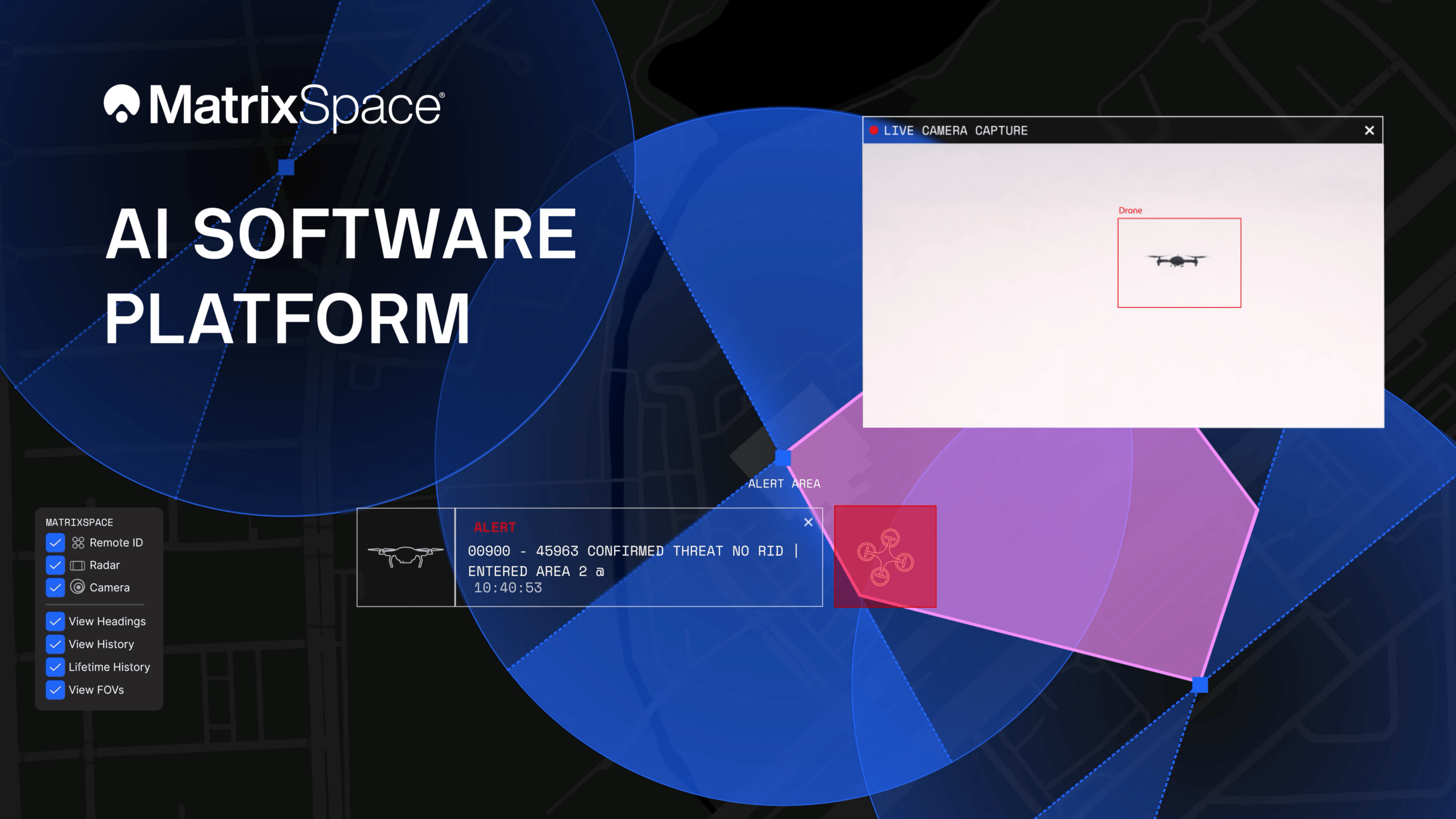
The MatrixSpace AI Software Platform consists of two core components: MatrixSpace AiEdge and MatrixSpace AiCloud.

AiEdge serves as the company’s intelligent sensor operating system. It runs directly on sensors and provides actionable intelligence at the point of data collection. Unlike platforms adapted later for artificial intelligence, both AiEdge and AiCloud are designed as AI-native systems. This design aims to make information faster to interpret and easier to act on.

Matt Kling, Vice President and General Manager of AI Systems at MatrixSpace, explained the motivation behind the update:

“Most traditional systems rely on noisy, exotic sensors with siloed, cumbersome command and control (C2) structures that hinder decisive action. But as threats of drone detection get only more complex, they require instant “threat truth”. Using AI to corroborate multiple inputs into one clear signal is the beauty of the MatrixSpace AI Software Platform, empowering customers to fully meet the threats we’re seeing today and in the future.”

AiEdge detects, classifies, and tracks multiple object types while filtering out clutter. The goal is to present operators with a relevant picture of aerial activity rather than raw sensor feeds.

Fusing Radar, Remote ID, ADS-B, and Optical Sensors at the Edge

AiEdge fuses detections from MatrixSpace radars with complementary sensors such as Remote ID and ADS-B. It correlates these inputs into a single, real-time track.

By combining data at the edge, AiEdge creates a common data representation and can cue pan-tilt-zoom (PTZ) cameras for fast visual confirmation. High-confidence tracks are then passed to the cloud for enterprise-level analysis.

This edge-based fusion allows local systems to continue operating even if cloud connectivity is lost. When connectivity is restored, activity data synchronizes automatically for later review.

Unified Airspace View Across Distributed Sites

MatrixSpace AiCloud sits above distributed AiEdge deployments. It simplifies the management of geographically diverse sensor networks into one unified view.

Instead of monitoring multiple individual sensor screens, operators can see low-altitude airspace activity, alerts, and warnings for all protected sites through a single interface. The system is accessible on any device.

AiCloud combines fused, real-time data from radar, optical, ADS-B, and Remote ID sensors. It supports consistent object tracking and actionable threat intelligence at scale. Within the platform, whitelisting and threat classification determine whether an object is friendly, unknown, or hostile. This enables faster and more coordinated responses.

Addressing Growing Counter-Drone Requirements

The update reflects growing demand for accurate, portable, and scalable counter-drone detection systems. Public safety agencies, infrastructure operators, and defense users increasingly need persistent awareness of low-altitude airspace. They also need systems that integrate into existing workflows rather than replace them.

MatrixSpace states that its AI-enabled platform is designed to provide persistent detection and classification for airspace, perimeter, and object monitoring in dynamic outdoor environments.

More information is available at www.matrixspace.com.

Read more:

  • DIU Announces MatrixSpace Winner of C-UAS Low-Cost Sensing Challenge
  • MatrixSpace Announces New Portable 360 C-UAS Radar System
  • MatrixSpace Wins Active Sensor Award in U.S. Army Operation Flytrap 4.5
Miriam McNabb

Miriam McNabb is the Editor-in-Chief of DRONELIFE and CEO of JobForDrones, a professional drone services marketplace, and a fascinated observer of the emerging drone industry and the regulatory environment for drones. Miriam has penned over 3,000 articles focused on the commercial drone space and is an international speaker and recognized figure in the industry.  Miriam has a degree from the University of Chicago and over 20 years of experience in high tech sales and marketing for new technologies.
For drone industry consulting or writing, Email Miriam.

TWITTER:@spaldingbarker

Subscribe to DroneLife here.

Filed Under: C-UAS, Drone News, Drone News Feeds, News Tagged With: ADS-B, AI software platform, airspace security, cloud-based AI, counter drone technology, Counter UAS, critical infrastructure security, Drone Detection, drone tracking, Edge Computing, MatrixSpace, multi-sensor fusion, PTZ cameras, Public Safety Drones, remote id

Reader Interactions

Leave a Reply Cancel reply

Your email address will not be published. Required fields are marked *

Primary Sidebar

LATEST

Teledyne FLIR OEM Upgrades Prism SKR Software for Autonomous Target Recognition

New release combines mission execution and intelligent supervision in a single autonomy platform Teledyne FLIR OEM has announced an upgrade…

Continue Reading Teledyne FLIR OEM Upgrades Prism SKR Software for Autonomous Target Recognition

Drone Operations Software Company AirHub Closes €4.4M Series A

AirHub, a European drone operations software company based in The Hague, has closed a €4.4 million Series A funding round.…

Continue Reading Drone Operations Software Company AirHub Closes €4.4M Series A

Arrive AI Patents Shared Drone Delivery Endpoint With Tenth U.S. Patent

Arrive AI (NASDAQ: ARAI) has secured its tenth U.S. patent, strengthening its intellectual property portfolio for autonomous drone delivery infrastructure.…

Continue Reading Arrive AI Patents Shared Drone Delivery Endpoint With Tenth U.S. Patent

Korean eVTOL Developer Airbility Partners on UAV Public Safety in Thailand

South Korean eVTOL developer Airbility has signed a four-party Memorandum of Understanding to deploy UAV systems for public safety and…

Continue Reading Korean eVTOL Developer Airbility Partners on UAV Public Safety in Thailand

Is U.S. Manufacturing the Answer? SKYROVER Signals a New Strategy as FCC Pressure Mounts

A Hong Kong-based drone company outlines a five-year U.S. roadmap, raising questions about compliance, supply chains, and market access A…

Continue Reading Is U.S. Manufacturing the Answer? SKYROVER Signals a New Strategy as FCC Pressure Mounts

Blue Marble Geographics and Avenza Systems Combine to Create Unified Geospatial Platform

Merger connects office-based analysis with field operations for end-to-end spatial workflows Blue Marble Geographics and Avenza Systems, Inc. have announced…

Continue Reading Blue Marble Geographics and Avenza Systems Combine to Create Unified Geospatial Platform

Amazon Prime Air Adjusts Course After Richardson Setbacks

After rocky start in Texas city, Amazon Air service flying high By DRONELIFE Features Editor Jim Magill After only a…

Continue Reading Amazon Prime Air Adjusts Course After Richardson Setbacks

Airspace Security at 2026 JUNO Awards

RF-Cyber counter-drone system enables non-disruptive protection for large public event D-Fend Solutions announced that its EnforceAir counter-drone system was deployed…

Continue Reading Airspace Security at 2026 JUNO Awards

Will States Be Ready with Counter Drone Tech for the FIFA World Cup?

Funding snafu, other issues delay counter-UAS ramp-up in Maryland, elsewhere By DRONELIFE Features Editor Jim Magill (Editor’s note: This is…

Continue Reading Will States Be Ready with Counter Drone Tech for the FIFA World Cup?

Strait of Hormuz Tensions Highlight a Growing Role for Small Drone Surveillance

Maritime risk, insurance pressure, and degraded navigation signals point to new use cases for commercial UAV systems Ongoing tension in…

Continue Reading Strait of Hormuz Tensions Highlight a Growing Role for Small Drone Surveillance

Secondary Sidebar

Footer

SPONSORED

Inspired Flight Gremsy IF800 VIO F1 drones geo week

What Will It Take to Strengthen U.S. Drone Manufacturing? A Conversation with Inspired Flight’s CEO

Global Mapper Mobile data collection

Collection Ground Control Points with Global Mapper Mobile

Military Drone Mapping Solutions

How SimActive’s Correlator3D™ is Revolutionizing Military Mapping: An Exclusive Interview with CEO Philippe Simard

Photogrammetry Accuracy Standards

SimActive Photogrammetry Software: Enabling Users to Meet Accuracy Standards for Over 20 Years

NACT Engineering Parrot ANAFI tether indoor shot

Smart Tether for Parrot ANAFI USA from NACT Engineering

Blue Marble, features global mapper, features Blue Marble

Check Out These New Features in Global Mapper v25 from Blue Marble

About Us | Contact Us | Advertise With Us | Write for Us | Privacy Policy | Terms of Service

The Trusted Source for the Business of Drones.

This website uses cookies and third party services. By clicking OK, you are agreeing to our privacy policy. ACCEPT

Manage consent

Privacy Overview

This website uses cookies to improve your experience while you navigate through the website. Out of these, the cookies that are categorized as necessary are stored on your browser as they are essential for the working of basic functionalities of the website. We also use third-party cookies that help us analyze and understand how you use this website. These cookies will be stored in your browser only with your consent. You also have the option to opt-out of these cookies. But opting out of some of these cookies may affect your browsing experience.
Necessary
Always Enabled
Necessary cookies are absolutely essential for the website to function properly. These cookies ensure basic functionalities and security features of the website, anonymously.
CookieDurationDescription
cookielawinfo-checkbox-analytics11 monthsThis cookie is set by GDPR Cookie Consent plugin. The cookie is used to store the user consent for the cookies in the category "Analytics".
cookielawinfo-checkbox-functional11 monthsThe cookie is set by GDPR cookie consent to record the user consent for the cookies in the category "Functional".
cookielawinfo-checkbox-necessary11 monthsThis cookie is set by GDPR Cookie Consent plugin. The cookies is used to store the user consent for the cookies in the category "Necessary".
cookielawinfo-checkbox-others11 monthsThis cookie is set by GDPR Cookie Consent plugin. The cookie is used to store the user consent for the cookies in the category "Other.
cookielawinfo-checkbox-performance11 monthsThis cookie is set by GDPR Cookie Consent plugin. The cookie is used to store the user consent for the cookies in the category "Performance".
viewed_cookie_policy11 monthsThe cookie is set by the GDPR Cookie Consent plugin and is used to store whether or not user has consented to the use of cookies. It does not store any personal data.
Functional
Functional cookies help to perform certain functionalities like sharing the content of the website on social media platforms, collect feedbacks, and other third-party features.
Performance
Performance cookies are used to understand and analyze the key performance indexes of the website which helps in delivering a better user experience for the visitors.
Analytics
Analytical cookies are used to understand how visitors interact with the website. These cookies help provide information on metrics the number of visitors, bounce rate, traffic source, etc.
Advertisement
Advertisement cookies are used to provide visitors with relevant ads and marketing campaigns. These cookies track visitors across websites and collect information to provide customized ads.
Others
Other uncategorized cookies are those that are being analyzed and have not been classified into a category as yet.
SAVE & ACCEPT