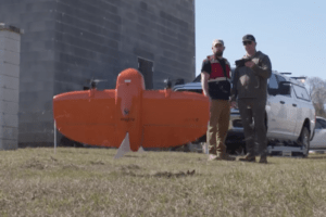
As hurricane season approaches, putting vital off-shore infrastructure at risk over the next few months, Verizon has announced a new partnership with the National Oceanic and Atmospheric Association to use uncrewed systems to rapidly survey storm damage immediately after major disasters. This three-year Cooperative Research and Development agreement is designed to integrate the personnel resources, flight equipment, and expertise of Verizon Frontline, Verizon’s in-house UAV division focused on infrastructure surveillance, with NOAA’s National Weather Service personnel.
The goal of the project is to increase the data-collection capability of NOAA after major storms and tornadoes. This allows them to improve their damage assessment capability while also gaining additional information on tornado and storm behavior with a goal of improving warnings and mitigation techniques.
“This collaboration has the potential to demonstrate how partnerships with Verizon and other organizations to gather drone imagery can significantly improve the services provided by the NWS to the public and partners when disaster strikes,” said Tim Oram, NWS Southern Region Headquarters Meteorological Services Branch Chief.
The CRADA applies to the Fort Worth, Texas-based NWS South region as well as NOAA’s National Severe Storms Laboratory. The deal will help protect the more than 77 million residents who live in the region, which is centered around the meteorologically active Gulf of Mexico and includes New Mexico, Texas, Oklahoma, Arkansas, Louisiana, Mississippi, Tennessee, Alabama, Georgia, and Florida, the Commonwealth of Puerto Rico and the U.S. Virgin Islands in the eastern Caribbean.
“This partnership will help pioneer new strategies aimed at gathering and disseminating crucial imagery, leveraging our collective expertise to enhance response efforts to severe storms and mitigate their impact on communities across the U.S.,” said Michael Adams, associate vice president for federal civilian services at Verizon.
Typically, after a storm, NOAA and the NWS deploy staff on the ground to survey storm damage, which can be dangerous and logistically difficult. Unmanned assets allow for more efficient information gathering, allowing for faster assignment of ratings and documentation of the storm’s path that researchers hope will improve future tornado and storm warnings.
“After a crisis, the first imagery that any emergency management agency or similar public safety agency gets is typically satellite data and the resolution isn’t ideal,” said Chris Sanders of the Verizon Frontline Crisis Response Team. “What we’re aiming to do through our partnership with NOAA is develop ways to get these agencies high-resolution imagery much faster than they can get it today by using our robust network and rapid-mapping capabilities.”
More information on the NOAA/Verizon partnership is available here.
Miriam McNabb is the Editor-in-Chief of DRONELIFE and CEO of JobForDrones, a professional drone services marketplace, and a fascinated observer of the emerging drone industry and the regulatory environment for drones. Miriam has penned over 3,000 articles focused on the commercial drone space and is an international speaker and recognized figure in the industry. Miriam has a degree from the University of Chicago and over 20 years of experience in high tech sales and marketing for new technologies.
For drone industry consulting or writing, Email Miriam.
TWITTER:@spaldingbarker
Subscribe to DroneLife here.