Continue reading below, or listen:
On the floor of the show today, DRONELIFE met Masataka Yamakawa, Marketing Director of Osaka, Japanese-based drone services company humorously named Amuse Oneself. The name is – well, amusing – but the application is serious: a green light LiDAR solution for aquatic applications.
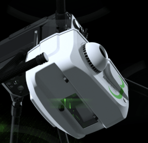
The 10-year old Amuse Oneself makes the TDOT GREEN lightweight LiDAR solution designed to be carried on a commercial, off the shelf aircraft or the company’s proprietary gas and electric hybrid drone, featuring a 2 hour flight endurance appropriate for long-range missions.
TDOT GREEN is a drone-mountable laser scanner system using green light, which is not easily absorbed by water. Delivering 60,000 pulses of laser per second toward the ground, the TDOT green can penetrate between 5 – 10 meters of water: the company is developing solutions that should increase the effective depth to 30 – 40 meters.
Right now, Amuse Oneself’s solutions are ideal for long surveys of shallow water, such as coastlines. In Japan, which has a coastline of more than 18,000 miles (about 30,000 km) the Japanese government uses the solution to map the coastline. The application can be a critical tool for climate change measurement and climate resilience efforts, as stakeholders use the 3D models of wet ground, shallow seabed, and riverbeds to establish water level baselines and study wildlife populations that may be affected by a change. In Israel, the company recently participated in a project to map the floor of the dead sea.
Amuse Oneself has converted their software and documentation from Japanese to English: costs of the solution varies according to the solution details but is in the range of $350,000 USD for the LiDAR camera, and about $100,000 USD for the proprietary gas-electric hybrid drone.
Read more about LiDAR mapping:
- Drone-Based LiDAR for Explosive Ordnance Disposal Units: More than Mapping
- Censys Adds LiDAR Options to Long-Range, BVLOS Fixed Wing
- For the Dark, Dirty and Dangerous, Flyability Elios 3 LiDAR Drone: Check Out this Fly Through a Decommissioned Nuclear Plant
- Drones to Manage Powerline Vegetation: Routescene UAV LiDAR
CEO DroneLife.com, DroneRacingLife.com, and CMO of Jobfordrones.com. Principle at Spalding Barker Strategies. Has enjoyed working with and around the commercial drone industry for the last 10 years. Attendance and speaker at Industry Events such as Commercial UAV, InterGeo, Interdrone and others. Proud father of two. Enjoys karate, Sherlock Holmes, and interesting things. Subscribe to all things drone at DroneLife here. Email is Harry@dronelife.com. Make Sure that you WhiteList us in your email to make sure you get our Newsletter. Editor1@dronelife.com.