Black Swift Technologies Delivers First-Of-Its-Kind UAS-Plus-Soil Moisture Sensor to Commercial Market: sophisticated drones for water management
By: Dawn Zoldi
On April 4th, Boulder, Colorado-based Black Swift Technologies (BST) initiated the commercial launch of an uncrewed aircraft system (UAS) equipped with a novel soil moisture sensor that will change the game for water management in agriculture and emergency response.
BST, a specialized engineering firm, is best known for developing resilient UAS designed for beyond-visual-line-of-sight flights in extreme environments, including on the side of volcanoes, over wildland fires and into hurricanes. The company’s UAS have flown on all seven continents, including the Arctic.
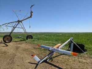
Its newest soil moisture mapping package consists of its fixed wing S2™ small UAS outfitted with a unique sensor payload, avionics and a radiometer. The design provides high resolution spatial and temporal images that penetrate the Earth’s surface to measure water content.
Using Drones for Water Management: A Better Solution
Currently, most organizations use satellite technology to monitor drought, predict flooding and assist in crop productivity. Due to lagging passover rates and resolution challenges, data gaps exist, especially at below-the-surface depths.
BST’s solution changes that. The modular architecture UAS platform design incorporates on-board passive microwave radiometers with a high revisit frequency. This provides timely and accurate insights into the dynamics of soil drainage and moisture retention at typical root depths. The instrument can cover areas up to 600 acres per flight.
The UAS has, at its core, a NASA flight-safety certified SwiftCore flight management system. It provides a level of autonomy and redundancy that enables routine and consistent data collection.
The avionics package consists of a networked advanced high performance autopilot system, intuitive user focused interface for flight end-to-end operational planning system and analysis and a portable ground station.
Tight integration between all of these components enables precision low-altitude flights in the range of 15m to 30m above ground level, at 5cm in depth with up to 15m in resolution. This allows customers to effectively diagnose problems early, conserve water, improve crop health and even predict environmental crises such as flash floods and wildland fires.
According to the World Resources Institute, water stress will continue to rise in many areas across the world due to increased water use and higher global temperatures. Global temperatures have resulted in dangerous and costly extreme weather events, including flash flooding in locations such as North Texas and Oklahoma and wildfires in Colorado. The data gleaned from BST’s S2/sensor package, through soil moisture mapping, has already provided life-saving alerts and warnings to these vulnerable watershed areas and to forecast wildfires.
According to Dr. Jack Elston, co-founder of Black Swift Technologies, this commercial launch is the culmination of a multi-year collaborative effort between BST, NASA and the Center for Environmental Technology (CET). The group also partnered with several university agricultural research groups and commercial entities.
In part, BST funded that effort through a 3-year, $875K NASA Small Business Innovation Research (SBIR) contract to develop not only the specialized radiometer, but also a custom airframe designed to be radio quiet, a requirement for accurate measurements. It included several years of flight campaigns over different crops, soil types, and terrain features that successfully proved BST’s concept of operations.
Elston said, “We are excited to finally get this advanced UAS, designed for soil moisture mapping, to market. We know this will greatly contribute to environmental sustainability. Our product can help with the planning and management of critical resources. It can help in the prevention and mitigation of weather-related disasters.” He continued, “We look forward to partnering with businesses and organizations involved in agriculture, land management, emergency management, homeland security as well as federal, state, local, tribal and territorial governments, now and in the future.”
Learn more about Black Swift Technologies:
- Black Swift Technologies on Dawn of Drones This Week
- Extreme BVLOS Flight with Black Swift Technologies, This Week on Dawn of Drones!
- Drone for Volcano Science: Black Swift Technology Creates UAS Observation Platform
- GPS-Denied Navigation: Black Swift Moves Drone Flight Forward with NOAA Contract
- Drones in Space: Black Swift Gets NASA Contract to Fly to Venus
Miriam McNabb is the Editor-in-Chief of DRONELIFE and CEO of JobForDrones, a professional drone services marketplace, and a fascinated observer of the emerging drone industry and the regulatory environment for drones. Miriam has penned over 3,000 articles focused on the commercial drone space and is an international speaker and recognized figure in the industry. Miriam has a degree from the University of Chicago and over 20 years of experience in high tech sales and marketing for new technologies.
For drone industry consulting or writing, Email Miriam.
TWITTER:@spaldingbarker
Subscribe to DroneLife here.