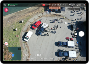
Ever since DroneDeploy launched in 2013, co-founders Mike Winn and Jono Millin have been working towards an ultimate goal – streamlining the process and eliminating the steps that it takes to process aerial imagery until processing drone maps becomes a one button process. Over the years, DroneDeploy has continued to get closer to the goal – and DroneDeploy’s summer release makes processing even easier for their clients.
DroneDeploy’s Summer Release
“One of our goals has always been to enhance the way our customers conduct business,” writes DroneDeploy. “Our feature releases have always been centered around growth and accessibility, and this July release is no different.” Here are just a few of the release’s new features, for more detail visit DroneDeploy’s blog for their product wrap-up.
More Accessible Data
As the drone industry expands, large enterprise is embracing the technology: and larger companies need a way to share data across the enterprise. “Many of our customers have large, diverse teams working in a variety of other platforms or geographic locations, and communication and collaboration – while using the latest site data – is key to business success, client transparency, and customer retention,” says DroneDeploy. The summer release makes it even easier to create and send project reports, bring geospatial datasets into DroneDeploy, and automatically view all maps within your GIS platform.
Enhanced Progress Reports
With DroneDeploy’s enhanced Progress Report, team members can get a full view of a project: and stakeholders can share visual project documentation in one, customizable report that can include maps, panoramas, videos, and photos of a project on a specific date, all with editable captions.
DroneDeploy’s summer release has built out the mission control center. “Real-time response and analytics, paired with airspace authorization and increased flight functionality, make this an end-to-end mission control solution for any operation,” says DroneDeploy.
“With DroneDeploy’s Missions, I can capture a map, pano, video, and progress photos in one flight, spending 40% less time on-site. I can now fly one extra site a day in the same amount of time using the same battery life,” says Matt Czuzak, Senior Virtual Construction Manager, Core Construction
LAANC Authorization in Partnership with Airbus UTM
LAANC authorization – the low altitude authorization and notification capability – has been key in improving operations for drone pilots everywhere. An integration with Airbus UTM brings that capability to DroneDeploy users.
Skydio 2 Integration
DroneDeploy is now fully integrated with the Skydio 2 drone. “This integration enables pilots to confidently avoid obstacles like cranes or oil wells while flying at low elevation,” says DroneDeploy. “The advanced obstacle avoidance features on Skydio 2 paired with the DroneDeploy flight app have enabled our teams to explore new types of drone missions that we were previously unable to execute safely, such as indoor and confined space inspections, and automated flight on sites with active tower cranes,” says Hunter Cole, Innovation & Operational Technology, Brasfield & Gorrie
Miriam McNabb is the Editor-in-Chief of DRONELIFE and CEO of JobForDrones, a professional drone services marketplace, and a fascinated observer of the emerging drone industry and the regulatory environment for drones. Miriam has penned over 3,000 articles focused on the commercial drone space and is an international speaker and recognized figure in the industry. Miriam has a degree from the University of Chicago and over 20 years of experience in high tech sales and marketing for new technologies.
For drone industry consulting or writing, Email Miriam.
TWITTER:@spaldingbarker
Subscribe to DroneLife here.