At this week’s InterDrone conference in Las Vegas, Michael Ritter of SlantRange gave a great presentation – and explained how drones may be able to completely revolutionize global agriculture.
Imagine aerial data that can tell you much, much more than which areas of your fields are planted and relatively healthy or the standard analysis received from comparing crops to vegetation health indexes. Get closer to that field and you might be able to see not just the broad view, but each individual plant in it.
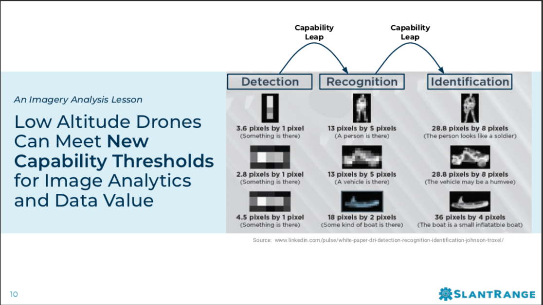
That’s not a new idea, says Ritter; but it’s new for agriculture. “Agricultural data relies on the resolution of images in much the same way that military images rely on resolution,” he says. “In the military, they rely on having images that can tell you the difference between a car and Humvee, or a walking stick and a gun – and they have done so for decades.”
Slide content property of Slantrange, used with express permission.
That kind of resolution is also critical to realizing the potential of aerial data in agriculture. “In agriculture, having resolution allows you to tell the difference between a weed and a corn plant,” says Ritter. “Higher resolution is important for crop analysis and decision making.”
Those data-driven decisions, says Ritter, have the potential to revolutionize agriculture – making it vastly more efficient. While some growers have asked how drone data can ever compete with free satellite data provided by seed companies, satellite data simply can’t achieve the same resolution and the same depth of information. “While Satellite data will continue to get better, it will never be as good as lower altitude level data,” Ritter points out. “…One problem with agriculture is that each crop is very specialized and somewhat unique: so having lower altitude, high resolution data sets allows farmers to customize solutions for their particular crops.”
When you are talking about scouting tens of thousands of agricultural acres per week, the cost of low altitude data gathered by manned aircraft like helicopters can be prohibitive. But as flight beyond visual line of sight (BVLOS) for drones becomes regularized, that cost will drop dramatically – and the data will become available for a much broader community of growers. Drones, says Ritter, have the potential to provide “Really valuable data products for about 1/10th of the price they are today.”
As drones become more automous and regulations such as BVLOS flight are developed, the world of agriculture will change. “Fully autonomous, robotic aircraft that can survey and treat thousands of agricultural acres per day at 1/10th the cost of today’s alternatives are on the horizon – and they are going to change farming practices around the world for the better,” says Ritter.
.
CEO DroneLife.com, DroneRacingLife.com, and CMO of Jobfordrones.com. Principle at Spalding Barker Strategies. Has enjoyed working with and around the commercial drone industry for the last 10 years. Attendance and speaker at Industry Events such as Commercial UAV, InterGeo, Interdrone and others. Proud father of two. Enjoys karate, Sherlock Holmes, and interesting things. Subscribe to all things drone at DroneLife here. Email is Harry@dronelife.com. Make Sure that you WhiteList us in your email to make sure you get our Newsletter. Editor1@dronelife.com.


[…] Click here for the full story Source: Dronelife […]