• Skip to main content
  • Skip to secondary menu
  • Skip to primary sidebar
  • Skip to secondary sidebar
  • Skip to footer
  • DroneRacingLife
  • DroneFlyers
  • Newsletter
DroneLife

DRONELIFE

Stay up to date on all the latest Drone News

  • News
  • Products
  • Industries
    • Agriculture
    • Construction
    • Delivery
    • Dual Use
    • Inspection
    • Public Safety
    • Surveying
  • Enthusiasts
  • Regulations
  • Business
  • Video
  • Podcasts

A Closer Look at senseFly’s New eBee X

September 17, 2018 by Malek Murison 8 Comments

Amid the avalanche of product and service launches, partnership announcements and general industry news at Interdrone earlier this month, senseFly, a division of French drone manufacturer Parrot, unveiled a new modular drone for aerial mapping and surveying.

On paper, the eBee X looks like a useful fixed-wing aircraft that should provide a rugged and adaptable solution for a range of mapping applications.

The eBee X

Parrot has plenty of experience with fixed-wing drones. Many industry watchers will be familiar with the company’s Disco drone, which looked like a lot of fun but ultimately lacked an addressable consumer market rather than any specific capability.

To date, fixed-wing flight and consumer aerial photography haven’t been a match made in heaven. But when it comes to mapping huge swathes of terrain and making survey flights as efficient as possible, fixed-wing is the way to go.

As such, the eBee X follows on from senseFly’s eBee SQ, Albris and eBee Classic models. It promises to be more suitable for harsh environments, offer longer flight times and greater adaptability than its predecessors.

The eBee X’s adaptability is enabled by a number of new camera options. It’s also backward compatible with some of Parrot/senseFly’s older imaging tools.

However, perhaps the most notable feature of senseFly’s new eBee X platform is how long it can stay n the air. The drone comes with an endurance extension feature that takes its flight time to 90 minutes and gives coverage to up to 500 ha (1,235 ac) at 400 ft (122 m).

Added to that is the ease with which it can be launched and landed. Users simply have to toss it into the air to get things started. The eBee X’s ‘Steep Landing’ tech means it can safely land in a confined area, while its designed to be rugged enough to withstand crash-style landings on any surface.

Read more: The Evolution of a Drone Company: Parrot Builds an End-to-End Business Solution

eBee X – New Camera Options

sensefly eBee X and cameras

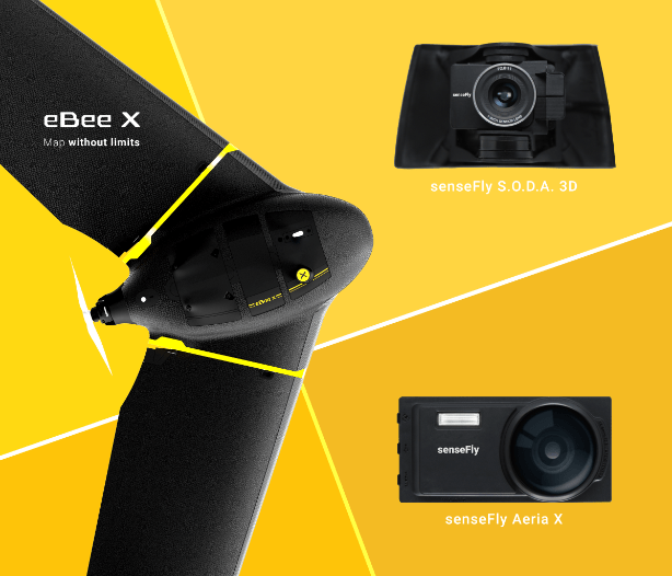
The eBee X includes a range of new camera options designed to suit every mapping job, from land surveying and topographic mapping to urban planning, crop mapping, thermal mapping, environmental monitoring and more. These cameras include:

  • The senseFly S.O.D.A. 3D: a unique drone photogrammetry camera with a one-inch sensor, which changes orientation during flight to capture three images (two oblique, one nadir) every time, instead of just one, for a much wider field of view. The result is stunning digital 3D reconstructions in vertically-focused environments—such as urban areas, open pit mines and coastlines—over larger areas than quadcopter drones can achieve. senseFly S.O.D.A. 3D is optimized for quick, robust image processing with Pix4Dmapper
  • The senseFly Aeria X: a compact drone photogrammetry camera with APS-C sensor. This rugged innovation offers an ideal blend of size, weight and DSLR-like image quality. Thanks in part to its built-in Smart Exposure technology, it provides outstanding image detail and clarity, in virtually all light conditions, allowing operators to map for more hours per day than ever before.
  • The senseFly Duet T: a dual-camera thermal mapping rig, which lets mapping professionals create geo-accurate thermal maps and digital surface models quickly and easily. The Duet T includes both a high-resolution (640 x 512 px) thermal infrared camera and a senseFly S.O.D.A. RGB camera with one-inch sensor. Both image sources can be accessed as required, while the rig’s built-in Camera Position Synchronisation feature works in sync with Pix4Dmapper photogrammetry software (optional) to simplify the map reconstruction process.

The eBee X is also compatible with the Parrot Sequoia+ multispectral camera for agriculture, the senseFly S.O.D.A. drone photogrammetry camera and senseFly Corridor for simple linear mapping.

Read more: Review: Hands On With the Parrot ANAFI

A leap forward for mapping tech

Speaking to Dronelife, Jean Thomas Célette, Chief Strategy and Product Officer Parrot Business Solutions, explained how the company’s reputation as an established end to end drone solution provider meant it can now more easily respond to customer feedback with new products and iterations.

“senseFly has been around for literally 10 years – we are now able to look at our data, and to talk to our customers about what’s really important to them,” he said. “Maintenance is important to them; the drone needs to be robust; they want even higher quality sensors – and increased the flight time. We took all of that feedback, and the experience drove the development process.”

“It’s something we’re really excited about – we took all of the data we had and implemented those ideas, and it was very collaborative with our customers.”

“The eBee X is a giant leap forward for mapping technology and underscores senseFly’s position as the leader in the fixed-wing drone market,” said Gilles Labossière, the Executive Vice President and COO of Parrot Group, and senseFly CEO.

“No matter what type of project a professional is undertaking, the eBee X has the coverage, data and accuracy capabilities needed to get the job done.”

Malek Murison
Malek Murison

Malek Murison is a freelance writer and editor with a passion for tech trends and innovation. He handles product reviews, major releases and keeps an eye on the enthusiast market for DroneLife.
Email Malek
Twitter:@malekmurison

Subscribe to DroneLife here.

Filed Under: Business and Finance, Drone News Feeds, Featured - Products, Fixed wing, Imaging, Mining and Aggregates, News, Technology Tagged With: commercial drone platform, ebee x, Fixed-wing, mapping, Parrot, senseFly

Reader Interactions

Trackbacks

  1. A free solar future, drones patrolling the skies above solar farms: pvMB 5/2/19 – pv magazine USA says:
    May 2, 2019 at 9:56 am

    […] designed specifically for solar farm inspections… The Solar 360 is a solution that combines the eBee X fixed-wing drone, senseFly’s Duet T thermal mapping camera, and Raptor Maps’ solar-specific software. senseFly […]

    Reply
  2. » senseFly Unveils Solar 360, a Thermal Fixed-Wing Drone for Solar Farm Inspections – DroneLifeSolar Equipment Installer says:
    May 1, 2019 at 4:41 am

    […] Solar 360 is a solution that combines the eBee X fixed-wing drone, senseFly’s Duet T thermal mapping camera, and Raptor Maps’ solar-specific software. senseFly […]

    Reply
  3. senseFly Unveils Solar 360, a Thermal Fixed-Wing Drone for S… – UAV – DRONEENEWS.COM says:
    May 1, 2019 at 4:09 am

    […] Solar 360 is a solution that combines the eBee X fixed-wing drone, senseFly’s Duet T thermal mapping camera, and Raptor Maps’ solar-specific software. senseFly […]

    Reply
  4. SenseFly to Support Brazil’s First BVLOS Drone Flights – Air and Ground says:
    April 28, 2019 at 7:06 pm

    […] Read more: A Closer Look at senseFly New eBee X […]

    Reply
  5. SenseFly to Support Brazil’s First BVLOS Drone Flights – UAV – DRONEENEWS.COM says:
    April 28, 2019 at 5:15 pm

    […] Read more: A Closer Look at senseFly New eBee X […]

    Reply
  6. SenseFly to Support Brazil's First BVLOS Drone Flights - Angle News says:
    April 28, 2019 at 3:38 pm

    […] Read more: A Closer Look at senseFly New eBee X […]

    Reply
  7. Showing off the senseFly eBee X at INTERGEO 2018 - Drones Crunch says:
    October 17, 2018 at 7:31 am

    […] Feedback has also seen an evolution of the support senseFly offers for the eBee X is also important to highlight, since rather than having to send in the whole drone itself for repairs, it’s now possible for users to make those repairs themselves, eliminating what could otherwise be lengthy downtime. It’s just another aspect of what sesneFly has referred to as a process that has been “collaborative with our customers.” […]

    Reply
  8. A Closer Look at senseFly’s New eBee X | Apis Insights says:
    September 17, 2018 at 6:49 pm

    […] Click here to view original web page at dronelife.com […]

    Reply

Leave a Reply Cancel reply

Your email address will not be published. Required fields are marked *

Primary Sidebar

LATEST

NASA Explores Airspace Prioritization for Public Safety Drone Operations

New testing examines how emergency responders can maintain priority access to airspace as commercial drone traffic grows As drone operations…

Continue Reading NASA Explores Airspace Prioritization for Public Safety Drone Operations

Why the ADS-B Fee Debate Matters for the Future of Drones and Shared Airspace

As lawmakers move to limit the use of ADS-B data for fee collection, the debate highlights broader issues around surveillance…

Continue Reading Why the ADS-B Fee Debate Matters for the Future of Drones and Shared Airspace

Grubhub and Dexa Launch New Jersey’s First Drone-Powered Food Delivery Program

Three-month pilot at Wonder’s Green Brook location will test drone delivery for local diners Grubhub has announced a new drone…

Continue Reading Grubhub and Dexa Launch New Jersey’s First Drone-Powered Food Delivery Program

Preparing for the World Cup: Collaboration and Training Take Center Stage in Counter-UAS Planning

Public safety leaders discuss interoperability, information sharing, and operational readiness At the DRONERESPONDERS National Conference held in Williamsburg, Virginia on…

Continue Reading Preparing for the World Cup: Collaboration and Training Take Center Stage in Counter-UAS Planning

FBI Outlines Pathway for State and Local Counter-Drone Authority

Safer Skies Act and new federal training programs shape the future of counter-UAS operations for public safety agencies At the…

Continue Reading FBI Outlines Pathway for State and Local Counter-Drone Authority

Ukraine’s Drone Industry Is Breaking Its Dependence on Chinese Parts

As Ukraine builds domestic drone components under wartime pressure, the effort offers lessons for manufacturers navigating new supply chain restrictions.…

Continue Reading Ukraine’s Drone Industry Is Breaking Its Dependence on Chinese Parts

WOMENDRONERESPONDERS Highlights Women Leaders and Future Talent at DRONERESPONDERS National Conference

Scholarships and industry support aim to encourage the next generation of women in public safety drone operations At the 2026…

Continue Reading WOMENDRONERESPONDERS Highlights Women Leaders and Future Talent at DRONERESPONDERS National Conference

Quantum Systems, Daimler Truck Launch MOSAIC Ground Autonomy Kit

Quantum Systems used LogNet 2026 in Koblenz to debut its MOSAIC Ground Autonomy Kit and formalize a new logistics autonomy…

Continue Reading Quantum Systems, Daimler Truck Launch MOSAIC Ground Autonomy Kit

Public Safety Drone Leaders Discuss What Comes Next for cUAS, BVLOS, and Airspace Integration

Leaders from the Hogan Lovells and the Commercial Drone Alliance and DRONERESPONDERS discuss cUAS authority, BVLOS progress, and airspace awareness…

Continue Reading Public Safety Drone Leaders Discuss What Comes Next for cUAS, BVLOS, and Airspace Integration

From Drones to Helicopters: Robinson, Ascent Build a Scalable Autonomous Rotorcraft Ecosystem

In an exclusive interview with Ascent AeroSystems CEO Paul Fermo: how Robinson and Ascent aim to scale autonomy from small…

Continue Reading From Drones to Helicopters: Robinson, Ascent Build a Scalable Autonomous Rotorcraft Ecosystem

Secondary Sidebar

Footer

SPONSORED

Inspired Flight Gremsy IF800 VIO F1 drones geo week

What Will It Take to Strengthen U.S. Drone Manufacturing? A Conversation with Inspired Flight’s CEO

Global Mapper Mobile data collection

Collection Ground Control Points with Global Mapper Mobile

Military Drone Mapping Solutions

How SimActive’s Correlator3D™ is Revolutionizing Military Mapping: An Exclusive Interview with CEO Philippe Simard

Photogrammetry Accuracy Standards

SimActive Photogrammetry Software: Enabling Users to Meet Accuracy Standards for Over 20 Years

NACT Engineering Parrot ANAFI tether indoor shot

Smart Tether for Parrot ANAFI USA from NACT Engineering

Blue Marble, features global mapper, features Blue Marble

Check Out These New Features in Global Mapper v25 from Blue Marble

About Us | Contact Us | Advertise With Us | Write for Us | Privacy Policy | Terms of Service

The Trusted Source for the Business of Drones.

This website uses cookies and third party services. By clicking OK, you are agreeing to our privacy policy. ACCEPT

Manage consent

Privacy Overview

This website uses cookies to improve your experience while you navigate through the website. Out of these, the cookies that are categorized as necessary are stored on your browser as they are essential for the working of basic functionalities of the website. We also use third-party cookies that help us analyze and understand how you use this website. These cookies will be stored in your browser only with your consent. You also have the option to opt-out of these cookies. But opting out of some of these cookies may affect your browsing experience.
Necessary
Always Enabled
Necessary cookies are absolutely essential for the website to function properly. These cookies ensure basic functionalities and security features of the website, anonymously.
CookieDurationDescription
cookielawinfo-checkbox-analytics11 monthsThis cookie is set by GDPR Cookie Consent plugin. The cookie is used to store the user consent for the cookies in the category "Analytics".
cookielawinfo-checkbox-functional11 monthsThe cookie is set by GDPR cookie consent to record the user consent for the cookies in the category "Functional".
cookielawinfo-checkbox-necessary11 monthsThis cookie is set by GDPR Cookie Consent plugin. The cookies is used to store the user consent for the cookies in the category "Necessary".
cookielawinfo-checkbox-others11 monthsThis cookie is set by GDPR Cookie Consent plugin. The cookie is used to store the user consent for the cookies in the category "Other.
cookielawinfo-checkbox-performance11 monthsThis cookie is set by GDPR Cookie Consent plugin. The cookie is used to store the user consent for the cookies in the category "Performance".
viewed_cookie_policy11 monthsThe cookie is set by the GDPR Cookie Consent plugin and is used to store whether or not user has consented to the use of cookies. It does not store any personal data.
Functional
Functional cookies help to perform certain functionalities like sharing the content of the website on social media platforms, collect feedbacks, and other third-party features.
Performance
Performance cookies are used to understand and analyze the key performance indexes of the website which helps in delivering a better user experience for the visitors.
Analytics
Analytical cookies are used to understand how visitors interact with the website. These cookies help provide information on metrics the number of visitors, bounce rate, traffic source, etc.
Advertisement
Advertisement cookies are used to provide visitors with relevant ads and marketing campaigns. These cookies track visitors across websites and collect information to provide customized ads.
Others
Other uncategorized cookies are those that are being analyzed and have not been classified into a category as yet.
SAVE & ACCEPT