• Skip to main content
  • Skip to secondary menu
  • Skip to primary sidebar
  • Skip to secondary sidebar
  • Skip to footer
  • DroneRacingLife
  • DroneFlyers
  • Newsletter
DroneLife

DRONELIFE

Stay up to date on all the latest Drone News

  • News
  • Products
  • Industries
    • Agriculture
    • Construction
    • Delivery
    • Dual Use
    • Inspection
    • Public Safety
    • Surveying
  • Enthusiasts
  • Regulations
  • Business
  • Video
  • Podcasts

AirMap Brings LAANC to Entire Drone Ecosystem

January 30, 2018 by Miriam McNabb 7 Comments

LAANC, the Low-Altitude Authorization and Notification Capability made available for testing last year, holds great promise for the industry. Now leading airspace management platform AirMap is bringing LAANC to the market, offering it to 3rd party developers and announcing new integrations.

LAANC is an important innovation, potentially eliminating the onerous process of applying for airspace authorizations.   The current application process can take up to 90 days, prompting some operators to complain that they lose lucrative work while waiting.  LAANC provides near real-time authorization.  The technology is so important to the drone industry that the FAA petitioned the Office of Management and Budget to bring the testing program forward; AirMap was one of the program’s initial testing partners.

“AirMap, the world’s leading airspace management platform for drones, today announced a feature that makes LAANC, the Low-Altitude Authorization and Notification Capability, available to the entire drone ecosystem,” announced AirMap. “With the FAA’s LAANC initiative, drone operators can apply for digital authorization to fly in U.S. controlled airspace near select FAA facilities.”

While the LAANC program is still in its test phase – available at 6 FAA facilities and 46 airports – the FAA plans to expand the LAANC program into a national beta starting in April.  “By the end of the year, more than 500 towered airports across the country will begin offering LAANC authorization,” says AirMap.

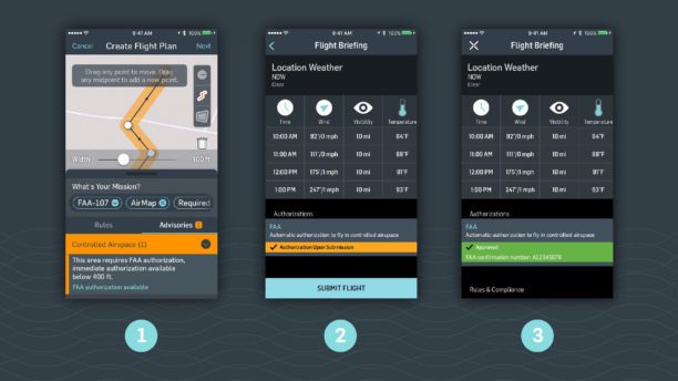
Drone developers and manufacturers can now integrate LAANC from AirMap into their own apps through deep linking. Industry innovators 3DR, Betterview, Converge, and DroneDeploy are the first to deploy LAANC Deep Linking from AirMap, now available to all with AirMap’s developer platform.

In participating apps, drone operators with an AirMap account are able to transfer their flight plan information to the AirMap app with just a tap. Once the authorization request has been submitted, drone operators are automatically redirected to the originating app to complete their flight.

LAANC authorization with AirMap is currently available from:

  • 3DR, makers of Site Scan, the complete drone data platform built for construction and engineering professionals.
  • Betterview, a building and property insights platform used by insurers to capture, organize, and analyze imagery from drone inspections.
  • Converge, an AI-powered app that turns drones into an essential team member working alongside humans to save businesses valuable time and money.
  • DroneDeploy, a commercial drone platform that improves industry workflows through scalable image processing, data storage, and collaborative drone maps and 3D models.

The following integrations will launch in February:

  • DroneBase, a scalable, affordable, and easy-to-integrate solution for enterprises to acquire drone imagery and data from its global pilot network.
  • Measure, the Drone as a Service® company that provides complete solutions to acquire, process, and deliver actionable aerial data to enterprise customers.

“With the LAANC beta launching nationwide by the end of the year, AirMap’s deep linking feature will bring digital authorization to an entire community of U.S. drone operators and developers eager to reach new heights,” said Ben Marcus, CEO of AirMap. “Thanks to LAANC, more airspace is open for business, and commercial drones have more opportunities to contribute to our economy and benefit our daily lives.”

“With this integration, it’s easier than ever for our customers to fly safely and confidently in the FAA’s controlled airspaces,” said Chris Anderson, CEO of 3DR. “This is a big next step in making commercial drones an essential tool on projects across the country.”

“LAANC is a key factor in seamlessly deploying drones in the commercial world,” said Paul Quimby, CTO of Converge. “Previously, we had users waiting up to 90 days to fly in restricted airspaces. Now, with a simple tap, our users can instantly request authorization to fly in airspaces from the FAA. By incorporating AirMap’s Deep Linking into our app, Control Tower, we are taking the next step in making drones a powerful accelerator of businesses’ existing workflows.”

“AirMap’s new LAANC Deep Linking has the potential to unlock greater operational efficiency for thousands of DroneDeploy customers across the construction, agriculture, and insurance industries,” said Ian Smith, Business Development Lead at DroneDeploy. “As a key technology partner in the industry’s largest drone app market, AirMap continues to help our customers operate safely.”


Miriam McNabb

Miriam McNabb is the Editor-in-Chief of DRONELIFE and CEO of JobForDrones, a professional drone services marketplace, and a fascinated observer of the emerging drone industry and the regulatory environment for drones. Miriam has penned over 3,000 articles focused on the commercial drone space and is an international speaker and recognized figure in the industry.  Miriam has a degree from the University of Chicago and over 20 years of experience in high tech sales and marketing for new technologies.
For drone industry consulting or writing, Email Miriam.

TWITTER:@spaldingbarker

Subscribe to DroneLife here.

Filed Under: Featured, News Tagged With: 3DR, AirMap, Betterview, converge, Drone airspace authorizations, DroneBase, DroneDeploy, FAA, LAANC

Reader Interactions

Trackbacks

  1. AirMap Names David Hose New CEO | News and Reviews about Drones, Quadcopter, Camera says:
    March 7, 2018 at 10:15 am

    […] AirMap has been a fast-moving success story since its inception in 2015.  In his post welcoming Hose to the CEO position, cofounder and Chairperson Ben Marcus says that the AirMap platform “serves more than 85% of the world’s drones and more than 100,000 flights each day.”  They’ve become a major player in the industry, collaborating with regulators and partners around the globe on UTM technology solutions and automated airspace authorizations (LAANC.) […]

    Reply
  2. North Carolina Aviation Division joins FAA Drone Integration Program | News and Reviews about Drones, Quadcopter, Camera says:
    February 11, 2018 at 1:31 am

    […] addition, NCDOT currently partners with UTM providers such as AirMap and North Carolina-based PrecisionHawk to innovate drone traffic management […]

    Reply
  3. North Carolina Aviation Division joins FAA Drone Integration Program – Drones Crunch says:
    February 10, 2018 at 11:15 pm

    […] addition, NCDOT currently partners with UTM providers such as AirMap and North Carolina-based PrecisionHawk to innovate drone traffic management […]

    Reply
  4. AirMap Brings LAANC to Entire Drone Ecosystem | Drone Magazine says:
    February 4, 2018 at 9:33 am

    […] Source […]

    Reply
  5. AirMap Brings LAANC to Entire Drone Ecosystem - Drone Services Company | Aerial Photo and Video | Miami Florida says:
    February 4, 2018 at 6:59 am

    […] post AirMap Brings LAANC to Entire Drone Ecosystem appeared first on […]

    Reply
  6. AirMap Brings LAANC to Entire Drone Ecosystem - King Drones Review | The Drones Kingdom says:
    February 3, 2018 at 11:45 pm

    […] post AirMap Brings LAANC to Entire Drone Ecosystem appeared first on […]

    Reply
  7. AirMap Brings LAANC to Entire Drone Ecosystem – Dronegram says:
    January 30, 2018 at 12:51 pm

    […] post AirMap Brings LAANC to Entire Drone Ecosystem appeared first on […]

    Reply

Leave a Reply Cancel reply

Your email address will not be published. Required fields are marked *

Primary Sidebar

LATEST

The Real FCC Drone Debate: Who Controls the Airwaves?

A closer look at how spectrum policy and licensing could determine the future of U.S. drone operations The FCC is…

Continue Reading The Real FCC Drone Debate: Who Controls the Airwaves?

Why Japan’s AAM Roadmap May Be the Most Realistic in the World

A phased, system-wide approach focuses on operations, infrastructure, and public acceptance Japan’s leading AAM provider, SkyDrive, has translated the country’s…

Continue Reading Why Japan’s AAM Roadmap May Be the Most Realistic in the World

DroneShield Opens European Headquarters in Amsterdam Amid Growing Counter-Drone Demand

DroneShield has officially opened its new European headquarters in Amsterdam, The Netherlands. The move strengthens the counter-drone company’s operational presence…

Continue Reading DroneShield Opens European Headquarters in Amsterdam Amid Growing Counter-Drone Demand

Mid-America Transplant Opens 160-Mile Drone Corridor for Organ Donation

Mid-America Transplant has become the first organ procurement organization (OPO) in the United States to use drones for donor blood…

Continue Reading Mid-America Transplant Opens 160-Mile Drone Corridor for Organ Donation

Manna Raises $50M to Expand Drone Delivery Network in the U.S.

Funding supports plans for 40 new bases and continued scaling of suburban UAV delivery operations Manna Air Delivery has announced…

Continue Reading Manna Raises $50M to Expand Drone Delivery Network in the U.S.

Terra Drone Invests in Ukraine-Based Interceptor Drone Company, Launches Terra A1

Partnership aims to scale low-cost defense solutions and expand global unmanned systems capabilities Terra Drone Corporation has announced a strategic…

Continue Reading Terra Drone Invests in Ukraine-Based Interceptor Drone Company, Launches Terra A1

FCC Seeks Input to Advance U.S. Drone Industry

Public notice outlines questions about regulatory reforms, spectrum access, and innovation zones The Federal Communications Commission (FCC) has opened a…

Continue Reading FCC Seeks Input to Advance U.S. Drone Industry

Skyports Deploys Automated BVLOS Drone Surveys for Major German Bridge Project

Remote-operated “drone-in-a-box” system delivers weekly 2D and 3D data for construction monitoring Skyports Drone Services has partnered with HOCHTIEF to…

Continue Reading Skyports Deploys Automated BVLOS Drone Surveys for Major German Bridge Project

Can You Get Survey-Grade Accuracy Without Ground Control Points?

New Study Explores When Drone Mapping Can Reduce Ground Setup A new white paper from Swiss drone manufacturer Wingtra takes…

Continue Reading Can You Get Survey-Grade Accuracy Without Ground Control Points?

April 2026 Public Safety Drone Review: Drones in Remote Environments and Operations on Lanai

DRONELIFE and DRONERESPONDERS host live webcast April 7 at 3 PM EST Register here for the next Public Safety Drone…

Continue Reading April 2026 Public Safety Drone Review: Drones in Remote Environments and Operations on Lanai

Secondary Sidebar

Footer

SPONSORED

Inspired Flight Gremsy IF800 VIO F1 drones geo week

What Will It Take to Strengthen U.S. Drone Manufacturing? A Conversation with Inspired Flight’s CEO

Global Mapper Mobile data collection

Collection Ground Control Points with Global Mapper Mobile

Military Drone Mapping Solutions

How SimActive’s Correlator3D™ is Revolutionizing Military Mapping: An Exclusive Interview with CEO Philippe Simard

Photogrammetry Accuracy Standards

SimActive Photogrammetry Software: Enabling Users to Meet Accuracy Standards for Over 20 Years

NACT Engineering Parrot ANAFI tether indoor shot

Smart Tether for Parrot ANAFI USA from NACT Engineering

Blue Marble, features global mapper, features Blue Marble

Check Out These New Features in Global Mapper v25 from Blue Marble

About Us | Contact Us | Advertise With Us | Write for Us | Privacy Policy | Terms of Service

The Trusted Source for the Business of Drones.

This website uses cookies and third party services. By clicking OK, you are agreeing to our privacy policy. ACCEPT

Manage consent

Privacy Overview

This website uses cookies to improve your experience while you navigate through the website. Out of these, the cookies that are categorized as necessary are stored on your browser as they are essential for the working of basic functionalities of the website. We also use third-party cookies that help us analyze and understand how you use this website. These cookies will be stored in your browser only with your consent. You also have the option to opt-out of these cookies. But opting out of some of these cookies may affect your browsing experience.
Necessary
Always Enabled
Necessary cookies are absolutely essential for the website to function properly. These cookies ensure basic functionalities and security features of the website, anonymously.
CookieDurationDescription
cookielawinfo-checkbox-analytics11 monthsThis cookie is set by GDPR Cookie Consent plugin. The cookie is used to store the user consent for the cookies in the category "Analytics".
cookielawinfo-checkbox-functional11 monthsThe cookie is set by GDPR cookie consent to record the user consent for the cookies in the category "Functional".
cookielawinfo-checkbox-necessary11 monthsThis cookie is set by GDPR Cookie Consent plugin. The cookies is used to store the user consent for the cookies in the category "Necessary".
cookielawinfo-checkbox-others11 monthsThis cookie is set by GDPR Cookie Consent plugin. The cookie is used to store the user consent for the cookies in the category "Other.
cookielawinfo-checkbox-performance11 monthsThis cookie is set by GDPR Cookie Consent plugin. The cookie is used to store the user consent for the cookies in the category "Performance".
viewed_cookie_policy11 monthsThe cookie is set by the GDPR Cookie Consent plugin and is used to store whether or not user has consented to the use of cookies. It does not store any personal data.
Functional
Functional cookies help to perform certain functionalities like sharing the content of the website on social media platforms, collect feedbacks, and other third-party features.
Performance
Performance cookies are used to understand and analyze the key performance indexes of the website which helps in delivering a better user experience for the visitors.
Analytics
Analytical cookies are used to understand how visitors interact with the website. These cookies help provide information on metrics the number of visitors, bounce rate, traffic source, etc.
Advertisement
Advertisement cookies are used to provide visitors with relevant ads and marketing campaigns. These cookies track visitors across websites and collect information to provide customized ads.
Others
Other uncategorized cookies are those that are being analyzed and have not been classified into a category as yet.
SAVE & ACCEPT