

The drone’s redundant communications system includes a proprietary line of sight radio and 3G/4G connectivity between the ground control station and the UAV using a worldwide machine-to-machine pre-paid plan. This builds on DELAIR’s experience with beyond visual line of sight (BVLOS) operations since 2012. The UX11 is ready for BVLOS flights with unlimited range and adds a new level of safety with this communication link.
“The UX11 by DELAIR is the ultimate solution for geospatial professionals that demand large-area mapping with centimeter-level precision,” said Michael de Lagarde, DELAIR’s CEO. “The UX11 will be capable of using its camera for enhanced safety procedures and even running early-stage pre-processing calculations onboard in real time using photogrammetry and deep learning algorithms. This expedites subsequent steps in the data processing chain for an optimized workflow. With the UX11, everything is done for a clear and efficient user experience.”
Survey-grade Results
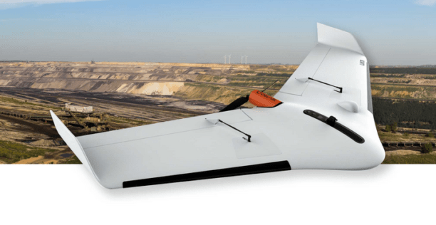
The UX11 is lightweight, stable, offers a hand-launch at takeoff and it lands using distance measuring technology. The Android mission planning software affords features such as support for in-flight camera feedback and live data review. Made to help professionals in GIS, survey, and construction optimize area coverage per flight, the UX11 flies for 59 minutes. The UX11 will be available for purchase via DELAIR’s global network of distributors by January, 2018. Pricing was not released.
End-to-end Solutions
The UX11 is a product offer for data acquisition which can be complemented by data processing and analytics software programs to address a range of commercial applications. The geospatial market will benefit from the ability to create 2D and 3D models and then generate elevation profiles, contour lines, slope qualifications and volumetric estimates with high accuracy and resolution using Post-Processed Kinematic (PPK) data and ground control points.


Frank Schroth is editor in chief of DroneLife, the authoritative source for news and analysis on the drone industry: it’s people, products, trends, and events.
Email Frank
TWITTER:@fschroth