If you’ve ever wondered what the difference is between 3D modeling and 3D mapping, you’re not alone. There is some overlap between the two in technology and solutions. We asked the experts at Pix4D to explain the difference.
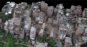
Pix4D is one of the leading providers of photogrammetry solutions for drones, creating both 2D and 3D information from images. Dr. Christoph Strecha, Pix4D’s founder and CEO, says that the difference is in how the data is used. “There is no difference scientifically,” explains Strecha. “A map is really 2D, something flat – but with modeling, the result is not a 2D map but a triangulated model where you can also see facades.”
3D Mapping
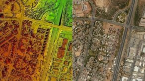
While the map is flat, most drone technology companies call it 3D mapping – because creating an accurate map from aerial images gives a result that doesn’t look anything like the kind of map you buy in a gas station. Instead, it’s a precise picture of terrain – including all of the buildings and natural components of the terrain. It can give a sense of size and depth. It’s often combined with other information, such as thermographic data or industry specific data (think agriculture crop counting systems) to make the map an actionable tool.


Data solutions use photogrammetry (the science of taking measurements from pictures) and orthomosaics to create 3D maps. Orthomosaics is a combination of processes. Ortho-rectifying or creating an orthophoto means adjusting an image for topographic relief, lens distortion, and camera tilt: allowing it to be used for true measurement. “Mosaics” is stitching together multiple images into one. The resulting maps – now highly accurate – can be used for a wide range of industrial applications, such as construction, surveying, urban planning, and land management.
3D Modeling
Strecha says that more and more clients now want to go beyond mapping into 3D modeling. “Even in traditional surveying and mapping, the needs are changing,” says Strecha. “On the professional side, there is more and more interest in 3D modeling.” Strecha uses the example of the ubiquitous Google maps – once strictly 2D but now giving users the experience of walking down a neighborhood street, viewing the houses.
While the equipment required is the same for both processes, drone operators who want a 3D model as a result will need to provide more oblique shots, providing images of the facades. With those, modeling software can create realistic 3D models or fly-through videos.
3D modeling can be used for commercial purposes like real estate; or, like the image at the top of the page, to create more informative maps.
Applications
There is good news for the drone operator: processing software and platforms can do all the work, building maps or models from the images they provide. The operator may just need to make their client aware of what’s available. While agronomists may still find 3D maps most useful, construction, geospatial or real estate applications are finding more benefit from 3D modeling.
Miriam McNabb is the Editor-in-Chief of DRONELIFE and CEO of JobForDrones, a professional drone services marketplace, and a fascinated observer of the emerging drone industry and the regulatory environment for drones. Miriam has penned over 3,000 articles focused on the commercial drone space and is an international speaker and recognized figure in the industry. Miriam has a degree from the University of Chicago and over 20 years of experience in high tech sales and marketing for new technologies.
For drone industry consulting or writing, Email Miriam.
TWITTER:@spaldingbarker
Subscribe to DroneLife here.
