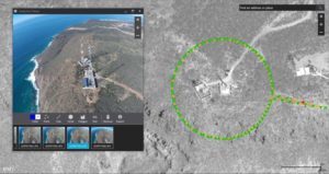
Last February, the California-based company released Drone2Map for ArcGIS, a powerful application that captures raw, drone-based image data and creates digital surface models, orthomosaics, 3D-point clouds and 3D Shareable PDFs. GIS users who lack the photogrammetry skills can leverage the software to transform raw drone data into GIS-ready products.
Fast forward to February 2017 as Esri prepares to release Drone2Map Version 1.1.
In a recent interview with Spar3D, Drone2Map product manager Anthony Mason explains that the new version builds on the programs ability to share layered tile displays – such as those seen in ArcGIS systems or Google Maps.
“What we’ve done is we’ve tied this back into the ArcGIS Enterprise environment. This is actually pretty big. Instead of creating dumb tiles that are nice to look at and draw really quickly, we’re actually letting you share the original data sets to ArcGIS Enterprise—including the full bit-depth and all the bands of the images.”
The upgrade also offers users easier access to ArcGIS Desktop, a robust geoprocessing framework that makes integrating various modeling tools into one process.
Adding more built-in functionality into Drone2Map solidifies Esri’s position as a dominant player in the GIS game for almost 50 years. The company boasts 9,000 employees in 67 nations. The company’s last annual sales figures stood at $900 million.
Drone2Map should prove to be a welcome tool in the world of inspection drones. The Inspection template in Drone2Map processes drone imagery and orients each image to the object being inspected. This allows users to quickly click on the map to select a “look angle” instead of searching through hundreds of photos to find proper angle.
“Drones are an emerging technology with the potential to revolutionize how we work across many industries,” said Esri president Jack Dangermond.
Jason is a longstanding contributor to DroneLife with an avid interest in all things tech. He focuses on anti-drone technologies and the public safety sector; police, fire, and search and rescue.
Beginning his career as a journalist in 1996, Jason has since written and edited thousands of engaging news articles, blog posts, press releases and online content.
Email Jason
TWITTER:@JasonPReagan
Subscribe to DroneLife here.