Guest post by DroneDeploy —
Project Managers Use Drone Maps to Communicate with Stakeholders, Monitor Progress and More
More and more, project managers are finding drone mapping to be an indispensable tool during all phases of construction. Easy-to-use software allows them to create high-resolution orthomosaic, elevation and 3D maps in a matter of hours. Combined with built-in measurement tools and annotations, they can keep real-time tabs on projects and identify potential issues before they become costly.
Cloud-based maps make sharing and collaborating with everyone from site engineers to project owners simple. Executives and offsite stakeholders stay informed and, because drone mapping is cost-effective, they see a return-on-investment almost immediately.
Overlay Plans with High-Resolution Maps to Catch Conflicts Sooner
Contract Project Manager Nick Johnson of Tilt Rock of Texas uses drone mapping to manage large, custom home projects. He has been in construction for forty years and a contractor-owner for twenty five years. When he began incorporating drones into his work, he saw immediate savings of both time and money.
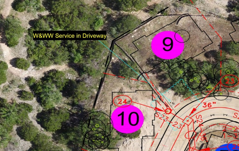
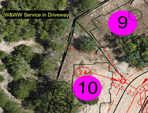
As the PM on a custom community with sixty seven homes, Johnson flew his drone over the site weekly and produced high-resolution maps that he overlaid with utility, wastewater and communications plans. Homeowners on this project made frequent changes to house footprints, models and orientation. But these overlays allowed him to stay informed with real-time data, catch conflicts with services before they actually happened and redirect them at minimum cost.

“If it weren’t for the drone maps, it would take me months to find out about many of these changes. Because aerial imagery identifies conflicts I wouldn’t normally see from the ground level, I find out about them in a matter of days.”- Nick Johnson [click to tweet]
Collaborate Virtually and Keep Stakeholders Informed
When a major American construction company built a million-square-foot distribution facility in which the ground was not level, they used drone mapping, combined with DroneDeploy’s measurement tools, to monitor the earth-moving process. The company worked with Uplift Data Partners, a drone services company, to help them capture drone imagery.
Andrew Dennison, COO of Uplift Data Partners, points out that drone mapping greatly improves communication both onsite and off. It is the quickest way to keep offsite stakeholders up to speed. “The project executive doesn’t feel the need to visit the site as often because he has a much better idea of how the site is progressing,” says Dennison.
DroneDeploy’s annotations feature allows project managers to convey information to multiple stakeholders with ease. Because maps are hosted on the DroneDeploy cloud, it is easy to share information through email or a hyperlink. “The construction company execs and the construction clients themselves can much more formally and neatly be updated on the progress.
In addition to keeping off-site management informed, the drone maps help PMs keep tabs on their sites more efficiently. DroneDeploy’s suite of high-resolution orthomosaic, 3-D and elevation maps allows them to drill down into key sections of a site. Area, distance and volume measurement tools provide an additional level of detail.
“The site managers don’t need to spend hours walking the site every day — they can check it on the drone imagery.” -Andrew Dennison [click to tweet]
A Cost-Effective Alternative to Surveying
Tumal Karunaratne uses drone mapping as a cost-effective alternative to traditional surveying. Karunaratne is a project engineer with Civil Solutions Associatiates, a geotechnical engineering company. In a matter of hours, he created an elevation map to assess the topography of a property in which the house was showing signs of damage from a landslide.
“Site evaluations [with a survey crew] could cost us five or ten thousand dollars…We’d much rather spend two thousand on a DJI drone, fly it ourselves and collect all the data we‘ll need.” -Tumal Karunaratne
Create Buy In from Management Low Entry Cost
For project managers looking to explore if drone mapping is right for their construction sites, Russ Gibbs of construction company Brasfield &Gorrie points out that low entry costs and a high return-on investment mean creating buy in from upper management isn’t difficult.
“The initial cost of drones is very low. You can get a DJI Phantom 4 at your local Apple store, work with DroneDeploy to test, and you’re up and running at a very low entry cost,” says Gibbs. “Because of that, we quickly had enough data to set up a presentation with management and as soon as they saw it, they understood it.”
To hear more from Gibbs, and his partners at Brasfield & Gorrie, about how they are using Drone Mapping to revolutionize their construction sites, watch our webinar: A Drone on Every Job Site: The Recap.
Frank Schroth is editor in chief of DroneLife, the authoritative source for news and analysis on the drone industry: it’s people, products, trends, and events.
Email Frank
TWITTER:@fschroth
