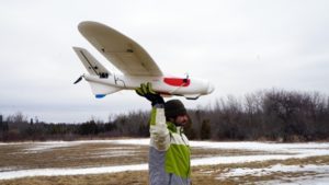
This past week, Canadian drone company Aeromao announced that the USDA Ungulate Disease and Damage research project will use the Aeromapper Talon fixed-wing drone to survey and map fire-damaged land.
In case you’re ever on Jeopardy, just remember that an ungulate pretty much covers the entire barnyard spectrum– horses, cattle and pigs — as well as forest-dwelling deer and elk.
As millions of acres are destroyed by wildfires, animal diseases such as bovine tuberculosis grow with the flames so conducting an accurate mapping survey is tantamount for conservation efforts.
Using the $9,000 Talon – equipped with a Micasense Rededge multispectral imagery array – researchers will be able to map acreage and survey damage to foliage that will help re-introduce wildlife and domestic mammals to viable land after the fires.
The Talon can stay aloft for 80 minutes per flight and is capable of autonomous missions via 3DR’s Pixhawk. Using Mission Planner software, the Talon offers swap-and-fly functions allowing additional sensors including thermal, Tetracam Snap and FPV.
With a wing-span of 6.5 feet and a maximum payload-plus weight of 7.7 pounds, the Talon is constructed of carbon-fiber reinforced foam. The drone lands via parachute and can fly up to 16,000 feet above sea level at a maximum cruise speed of 31 mph.
Although amateur rogue drone pilots have interfered with wildfire-fighting efforts this past year, the USDA’s new drone mission is another example of drones helping post-blaze recovery. A similar “Drone for Good” wildfire project is a partnership that includes Olin College, MIT and UAV firm Scientific Systems to develop a vanguard of self-flying drones that could gather airborne, real-time data to send to crews fighting dangerous wildfires.
The drones won’t be able to literally fight the fires but they will converge to create real-time data sets for firefighters and other emergency officials. Logistical data can help experts pinpoint how the fire is likely to spread and how best to deploy on-the-ground crews.
Jason is a longstanding contributor to DroneLife with an avid interest in all things tech. He focuses on anti-drone technologies and the public safety sector; police, fire, and search and rescue.
Beginning his career as a journalist in 1996, Jason has since written and edited thousands of engaging news articles, blog posts, press releases and online content.
Email Jason
TWITTER:@JasonPReagan
Subscribe to DroneLife here.