• Skip to main content
  • Skip to secondary menu
  • Skip to primary sidebar
  • Skip to secondary sidebar
  • Skip to footer
  • DroneRacingLife
  • DroneFlyers
  • Newsletter
DroneLife

DRONELIFE

Stay up to date on all the latest Drone News

  • News
  • Products
  • Industries
    • Agriculture
    • Construction
    • Delivery
    • Dual Use
    • Inspection
    • Public Safety
    • Surveying
  • Enthusiasts
  • Regulations
  • Business
  • Video
  • Podcasts

Value Chain Analysis for UAV-based Surveying in the Construction Industry

November 9, 2016 by Frank Schroth Leave a Comment

Guest post by Kay Wackwitz, Drone Industry Insights —

value-chain-analysis-uav-based-surveyingSmall UAVs, as compared to manned aircraft, convince through their ability to fly very slowly and at lower altitudes. This way, more detailed and valuable information can be obtained. UAVs close the gap (between ground- and aircraft/satellite-based methods) through their ability to fly at low altitudes (up to 100m), which cannot be covered by the alternatives mentioned previously.

It should be mentioned that compared to other options, UAVs are rather limited in terms of the amount of payload they can carry. This is why light, non-professional consumer cameras are generally used, although they cannot match the quality of stable metric cameras. Yet, even with those comparatively inexpensive cameras, it is possible to attain results that are more than sufficient for the needs of the construction industry.

– Prof. Thomas P. Kersten, HafenCity University Hamburg, Geomatics Lab

Now, what does this mean for you business?

The possibility to shorten the surveying process through the support of UAV solutions contains the potential to enormously reduce the time and monetary investment – for every project, for every surveying company and in every country. Surveyors can not only increase their productivity by being able to carry out more projects in the same amount of time, but they can also work with a more qualitative dataset, which makes it possible to conduct better, more thorough planning.

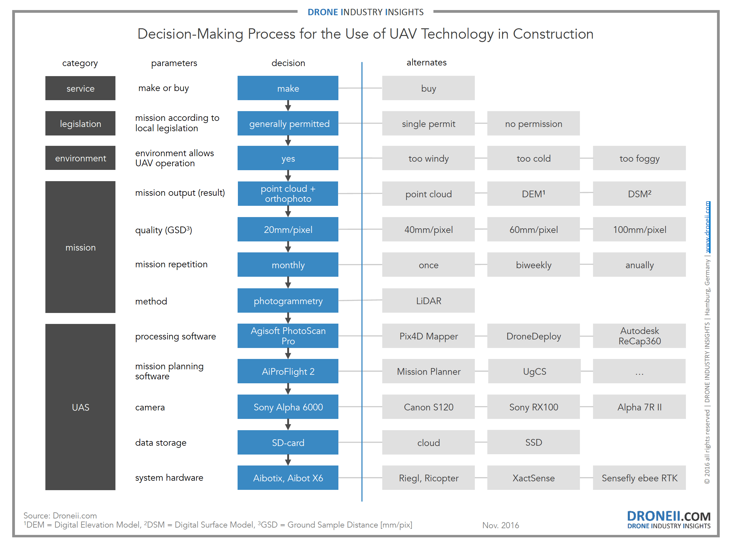
To make the right decisions it is important to define the results you need. Therefore you can use the inverse decision-making process below. After the initial question if you want to hire a professional drone operator or starting a drone operation yourself it necessary to have a close look at the local regulations and environmental conditions. Once the mission and all aspects of operation are clear, you can start to configure the unmanned aerial system (UAS). With all information describing your plans (incl. fixed and operational costs) you can now chose again whether to start your own drone operation or to buy in the service.

Click on the image for more info

decision-making-process-for-the-use-of-uav-technology-for-constructionWhere exactly can I save money and how much?

Looking at the entire value chain it becomes clear that many resource- and time-intensive activities can be replaced. Looking at repetitive activities (e.g. checking construction progress of the same location), the savings through UAV operation can be even greater.

The report “Value Chain Analysis for UAV-based Surveying” represents the essence of what you need to know if you consider using drone technology. It offers a detailed outline of technological, legal and operational aspects of UAV application in comparison to conventional surveying methods. The question when UAV technology in the construction industry pays off economically is discussed in detail.

In addition to the Drone Business Development Guide 2016 which outlines the basics of a UAV market entry, this report is mission specific and provides the most comprehensive analysis about commercial UAVs in action so far. This report was created with the support of construction surveying and UAV experts.

In case you have missed one of our previous articles:

  • TOP20 Drone Company Ranking Q3 2016
  • The Drone Market Environment Map 2016
Frank Schroth
Frank Schroth

Frank Schroth is editor in chief of DroneLife, the authoritative source for news and analysis on the drone industry: it’s people, products, trends, and events.
Email Frank
TWITTER:@fschroth

Filed Under: Applications, Construction, Droneii, News Tagged With: Construction, droneii

Reader Interactions

Leave a Reply Cancel reply

Your email address will not be published. Required fields are marked *

Primary Sidebar

LATEST

Titan Protection Receives FAA Approval for One-to-Many Drone Operations

Titan Protection has secured FAA approval to conduct one-to-many drone operations, enabling a single remote pilot to oversee up to…

Continue Reading Titan Protection Receives FAA Approval for One-to-Many Drone Operations

DroneOD Joins Space Park Leicester to Advance Cross-Platform Drone Technologies

DroneOD, a UK start-up developing universal connectivity solutions for unmanned aerial systems, has joined Space Park Leicester at its £100…

Continue Reading DroneOD Joins Space Park Leicester to Advance Cross-Platform Drone Technologies

Autoflight Unveils First 5-Ton Heavy Lift eVTOL Aircraft

AutoFlight has introduced Matrix, the world’s first 5-ton eVTOL aircraft, successfully completing a public full transition flight demonstration at its…

Continue Reading Autoflight Unveils First 5-Ton Heavy Lift eVTOL Aircraft

FAA Signals Tougher Stance on Unauthorized Drone Operations

Agency issues fines, license suspensions, and revocations for unsafe and unauthorized drone operations The Federal Aviation Administration (FAA) took enforcement…

Continue Reading FAA Signals Tougher Stance on Unauthorized Drone Operations

New DIU Project Targets Scalable, Containerized Drone Launch and Recovery Systems

DoD Seeks Automated Infrastructure to Support Large-Scale Autonomous Drone Operations The U.S. Department of Defense (DoD), through the Defense Innovation…

Continue Reading New DIU Project Targets Scalable, Containerized Drone Launch and Recovery Systems

The Companies Tapped for the Pentagon’s Drone Dominance Push

U.S. Department of War Launches Industry Competition for Drone Dominance Program Phase I The U.S. Department of War has formally…

Continue Reading The Companies Tapped for the Pentagon’s Drone Dominance Push

MatrixSpace Expands AI Software Platform to Enable Multi-Sensor, Real-Time Counter-Drone Detection

Updated edge-to-cloud architecture supports early warning, threat assessment, and unified airspace awareness MatrixSpace has announced a major update to its…

Continue Reading MatrixSpace Expands AI Software Platform to Enable Multi-Sensor, Real-Time Counter-Drone Detection

Why “Best-in-Class” Components Aren’t Enough Anymore

How sourcing expectations are changing how drones are engineered Amprius’ newly announced U.S.-based manufacturing partnership with Nanotech Energy is more…

Continue Reading Why “Best-in-Class” Components Aren’t Enough Anymore

SkyDrive to Demonstrate Remotely Piloted eVTOL Operations in Tokyo

Japan-based eVTOL developer SkyDrive Inc. will conduct demonstration flights of its Model SD-05 in Tokyo between February 24 and February…

Continue Reading SkyDrive to Demonstrate Remotely Piloted eVTOL Operations in Tokyo

Chemitek Solar Develops Drone-Compatible Cleaning Solution for Agrivoltaic Systems

Portuguese manufacturer Chemitek Solar has announced the development of its Drone AgroPV Cleaning Agent, a specialized biodegradable cleaning solution engineered…

Continue Reading Chemitek Solar Develops Drone-Compatible Cleaning Solution for Agrivoltaic Systems

Secondary Sidebar

Footer

SPONSORED

Inspired Flight Gremsy IF800 VIO F1 drones geo week

What Will It Take to Strengthen U.S. Drone Manufacturing? A Conversation with Inspired Flight’s CEO

Global Mapper Mobile data collection

Collection Ground Control Points with Global Mapper Mobile

Military Drone Mapping Solutions

How SimActive’s Correlator3D™ is Revolutionizing Military Mapping: An Exclusive Interview with CEO Philippe Simard

Photogrammetry Accuracy Standards

SimActive Photogrammetry Software: Enabling Users to Meet Accuracy Standards for Over 20 Years

NACT Engineering Parrot ANAFI tether indoor shot

Smart Tether for Parrot ANAFI USA from NACT Engineering

Blue Marble, features global mapper, features Blue Marble

Check Out These New Features in Global Mapper v25 from Blue Marble

About Us | Contact Us | Advertise With Us | Write for Us | Privacy Policy | Terms of Service

The Trusted Source for the Business of Drones.

This website uses cookies and third party services. By clicking OK, you are agreeing to our privacy policy. ACCEPT

Manage consent

Privacy Overview

This website uses cookies to improve your experience while you navigate through the website. Out of these, the cookies that are categorized as necessary are stored on your browser as they are essential for the working of basic functionalities of the website. We also use third-party cookies that help us analyze and understand how you use this website. These cookies will be stored in your browser only with your consent. You also have the option to opt-out of these cookies. But opting out of some of these cookies may affect your browsing experience.
Necessary
Always Enabled
Necessary cookies are absolutely essential for the website to function properly. These cookies ensure basic functionalities and security features of the website, anonymously.
CookieDurationDescription
cookielawinfo-checkbox-analytics11 monthsThis cookie is set by GDPR Cookie Consent plugin. The cookie is used to store the user consent for the cookies in the category "Analytics".
cookielawinfo-checkbox-functional11 monthsThe cookie is set by GDPR cookie consent to record the user consent for the cookies in the category "Functional".
cookielawinfo-checkbox-necessary11 monthsThis cookie is set by GDPR Cookie Consent plugin. The cookies is used to store the user consent for the cookies in the category "Necessary".
cookielawinfo-checkbox-others11 monthsThis cookie is set by GDPR Cookie Consent plugin. The cookie is used to store the user consent for the cookies in the category "Other.
cookielawinfo-checkbox-performance11 monthsThis cookie is set by GDPR Cookie Consent plugin. The cookie is used to store the user consent for the cookies in the category "Performance".
viewed_cookie_policy11 monthsThe cookie is set by the GDPR Cookie Consent plugin and is used to store whether or not user has consented to the use of cookies. It does not store any personal data.
Functional
Functional cookies help to perform certain functionalities like sharing the content of the website on social media platforms, collect feedbacks, and other third-party features.
Performance
Performance cookies are used to understand and analyze the key performance indexes of the website which helps in delivering a better user experience for the visitors.
Analytics
Analytical cookies are used to understand how visitors interact with the website. These cookies help provide information on metrics the number of visitors, bounce rate, traffic source, etc.
Advertisement
Advertisement cookies are used to provide visitors with relevant ads and marketing campaigns. These cookies track visitors across websites and collect information to provide customized ads.
Others
Other uncategorized cookies are those that are being analyzed and have not been classified into a category as yet.
SAVE & ACCEPT