
The University of Southern California Spatial Sciences Institute offers flexible, online degree and certificate programs that provide the education -and the respected credentials - required to succeed in using drones for GIS mapping. Read on to learn more about how the University of Southern California is helping to shape the way GIS professionals gather data. How GIS … [Read more...] about USC Spatial Sciences Institute Offers the Education You Need to Use Drones in GIS Mapping
drones in mapping
Aerial Surveying: DJI Introduces 2 New Powerful Payloads
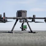
This week the INTERGEO conference takes place: the world's biggest conference for the geospatial industry. Drones have become such a big part of the geospatial industry that there is now a dedicated section of the show for them: INTERAERIAL Solutions focuses on aerial surveying using drones. At Intergeo today, the world's largest drone manufacturer, DJI announced two new … [Read more...] about Aerial Surveying: DJI Introduces 2 New Powerful Payloads


