
Unlocking the Power of Pixels: Efficient 3D Data Creation with Global Mapper Pro’s Pixels to Points Tool
Sponsored Content. The all-in-one geospatial software, Global Mapper Pro®, really does it all! From raster data viewing and editing to vector feature creation, Global Mapper Pro goes further to include tools for point cloud analysis and classification. The Pixels to Points® tool in Global Mapper Pro even enables users to create 3D data from overlapping drone/UAV-collected images.
The Pixels to Points tool uses an overlapping, geotagged image set as an input to generate a seamless orthoimage, point cloud, and textured 3D mesh. These outputs are created using structure from motion analysis, a process which creates very high-resolution data outputs. The use of surveyed ground control points in the Pixels to Points tool will help enhance the positional accuracy of the created data layers.
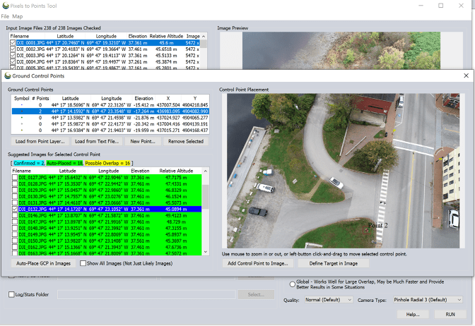
In Global Mapper Pro version 26.0, ground control points can be automatically identified, improving on the previous workflow that included the tedious task of individually tagging each control point in each image. Automatic ground control point placement uses the control point location and calculated image coverage polygon for each image to identify candidate images where a ground control point may appear. The user then identifies the control point target. This might be a manually placed target board, or a fixed and identifiable feature on the ground, such as a manhole cover. The user then asks the Pixels to Points tool to place the control point in all images where the target is found. The user can then adjust and confirm the control point placements as needed before running Pixels to Points to generate the high-resolution data outputs.
Global Mapper 26.0 also boasts a significant reduction in processing time in the Pixels to Points tool. Improvements and optimizations to the underlying processes in the Pixels to Points data creation process produced up to 50% improvements in processing time. Generating high-quality 3D datasets from drone/UAV-collected images makes Global Mapper Pro an even more valuable tool across many industries.

Check out bluemarblegeo.com/global-mapper-pro for more information on how a point cloud creation workflow can continue in Global Mapper Pro with cutting-edge point cloud analysis and classification tools. Download Global Mapper Pro version 26.0 to try out Pixels to Points and the many other tools, including a new deep learning-based image analysis toolset in the new Global Mapper Insight and Learning EngineTM.
Read more:
- Check Out These New Features in Global Mapper v25 from Blue Marble
- From the Floor of Intergeo: Blue Marble Global Mapper V24, More Resolution, More Speed


Miriam McNabb is the Editor-in-Chief of DRONELIFE and CEO of JobForDrones, a professional drone services marketplace, and a fascinated observer of the emerging drone industry and the regulatory environment for drones. Miriam has penned over 3,000 articles focused on the commercial drone space and is an international speaker and recognized figure in the industry. Miriam has a degree from the University of Chicago and over 20 years of experience in high tech sales and marketing for new technologies.
For drone industry consulting or writing, Email Miriam.
TWITTER:@spaldingbarker
Subscribe to DroneLife here.