


Finding FAA-Recognized Identification Areas Made Easier with New Online Map
With the arrival of summer, drone enthusiasts are gearing up for more outdoor activities. As drone flying gains popularity, it’s crucial for pilots to adhere to FAA regulations, including the Remote ID rule, which requires all registered drones to broadcast identification and location information while in flight.
To assist drone operators, the FAA has released an updated map of FAA-Recognized Identification Areas (FRIAs). FRIAs are specific locations where drones can be flown without Remote ID equipment. This new tool simplifies the process of locating these areas, ensuring pilots can easily find a nearby FRIA to comply with the regulations.
Understanding Remote ID Requirements
The Remote ID rule is part of the FAA’s effort to integrate drones into the National Airspace System (NAS) safely. It mandates that all drones requiring registration must broadcast identification and location information. This capability helps the FAA, law enforcement, and other federal agencies to locate drones that might be operating unsafely or in restricted areas.
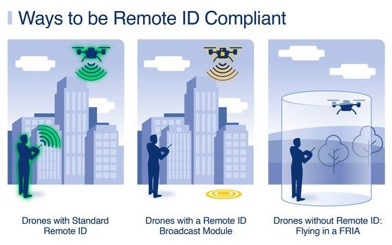
Ways to Comply with Remote ID:
- Fly a Standard Remote ID Drone: These drones come with built-in Remote ID broadcast capabilities, providing real-time identification and location information.
- Use a Remote ID Broadcast Module: For drones without built-in Remote ID, operators can attach a broadcast module. This device sends out the necessary information and must be listed in the drone’s registration.
- Fly in a FRIA: Drones without Remote ID equipment can be flown in designated FAA-Recognized Identification Areas.

For more information on how to comply with Remote ID, visit the FAA’s Remote Identification of Drones page.
What Are FRIAs?
FRIAs are defined geographic areas where drones can operate without Remote ID. Both the drone and the pilot must remain within the FRIA’s boundaries during the flight, and the drone must be within the visual line of sight of the pilot at all times.
Standard Remote ID drones and drones equipped with a Remote ID broadcast module can also fly within a FRIA, but they must still broadcast their Remote ID information.
To locate a FRIA near you, check out the FAA’s new FRIA Locations Map. This resource is part of the FAA’s UAS Data Delivery System, providing valuable data to drone pilots and stakeholders.
Who Can Apply for a FRIA?
Only FAA-recognized Community Based Organizations (CBOs) and educational institutions such as primary and secondary schools, trade schools, colleges, and universities can apply for FRIA status. Applications are processed through the FAADroneZone website.
For additional details on FRIA applications, refer to Advisory Circular 89-3 and 14 CFR Part 89.
Getting Ready to Fly
Before taking flight, ensure your drone meets all FAA requirements. For more detailed guidance on registering drones, Remote ID compliance, and other safety tips, visit the FAA website.
The new FRIA map is a significant step towards making drone operation easier and safer for pilots. By following these guidelines, drone enthusiasts can enjoy their flights while staying compliant with FAA regulations.
Read more:
- FAA Reauthorization Act Enhances Recreational Drone Operations: Key Amendments and Impacts for Flyers and Educators
- GAO Report: Remote ID Not Living Up to Potential
- Commercial Drone Alliance, AUVSI Release FAA’s Drone Remote ID Rule FAQ


Miriam McNabb is the Editor-in-Chief of DRONELIFE and CEO of JobForDrones, a professional drone services marketplace, and a fascinated observer of the emerging drone industry and the regulatory environment for drones. Miriam has penned over 3,000 articles focused on the commercial drone space and is an international speaker and recognized figure in the industry. Miriam has a degree from the University of Chicago and over 20 years of experience in high tech sales and marketing for new technologies.
For drone industry consulting or writing, Email Miriam.
TWITTER:@spaldingbarker
Subscribe to DroneLife here.