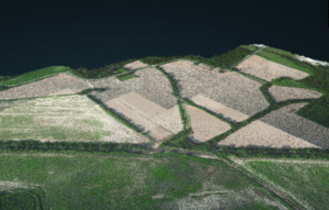
Lidar data can be tricky to understand, however. Without the context of traditional imagery, Lidar requires users to interpret what they are seeing. Lidar scanners don’t typically capture color, including only elevation or intensity values.
Now, SimActive Inc. announces the use of its lidar point cloud colorization capabilities by users of multi-sensor systems developed by LiDARUSA. SimActive’s Correlator3D™ software allows to profit from imagery and Lidar data in a complimentary fashion: making Lidar data easy to understand.
Lidar point clouds are first imported in Correlator3D™, to which the collected imagery is automatically registered. The lidar data are used as control for the registration process. Each lidar point is then colorized using the images.
“While lidar is great, everyone understands imagery. Colorizing lidar makes the data much more understandable”, said Jeff Fagerman, CEO at LiDARUSA. “Correlator3D allows our clients to easily colorize lidar point clouds from their multi-camera system.”
SimActive is the developer of Correlator3D™ software, a patented end-to-end photogrammetry solution for the generation of high-quality geospatial data from satellite and aerial imagery, including drones.
Read more:
- From the floor of Intergeo: Simactive, Mapping Spaces from Countries to Construction Sites
- SimActive and Phase One IIQ Integration: Faster Processing, Easier Data Management
- Drone Mapping in Construction: SimActives Correlator 3D in the Field in Texas
- Creating Colorized Point Clouds, Reflective Calibration, and More: Diving into SimActives New Features
- Mapping and LiDAR: SimActive Integrated with LiDAR Solution for Drones
Miriam McNabb is the Editor-in-Chief of DRONELIFE and CEO of JobForDrones, a professional drone services marketplace, and a fascinated observer of the emerging drone industry and the regulatory environment for drones. Miriam has penned over 3,000 articles focused on the commercial drone space and is an international speaker and recognized figure in the industry. Miriam has a degree from the University of Chicago and over 20 years of experience in high tech sales and marketing for new technologies.
For drone industry consulting or writing, Email Miriam.
TWITTER:@spaldingbarker
Subscribe to DroneLife here.