


As summer heats up, experts are expecting another scorching forest-fire season—especially with the added uncertainty fanned by climate change. However, Toledo University is finding new ways to predict forest fires using drone technology.
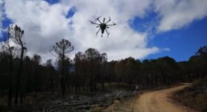
Partnering with European drone LiDAR solution provider Routescene, the university assessed a forest-fire site in the Spanish province of Albacete to study the blaze’s severity and distribution more precisely.
“Wildfires don’t burn evenly through forests, some areas may be barely touched, whilst in other areas, most of the trees and foliage will be severely damaged,” a Routescene press release notes.
“The findings showed that UAV LiDAR data provided ecologically meaningful metrics which can be used to predict fire risk, develop more precise, site-specific fire impact studies and create post-fire management plans.”
Because satellite optical imagery can’t penetrate through a forest canopy, researchers use drones equipped with Routescene’s LiDAR system and data analysis in Routescene’s LidarViewer Pro software to create Digital Terrain Models (DTMs) and Canopy Height Models.
The system’s lasers penetrate through gaps in foliage to detect and capture data from individual trees while also establishing a vertical profile of the canopy and vegetation.
‘The obvious next choice’


“UAV LiDAR surveying, with its level of detail, was the obvious next choice of technology and a natural evolution to further examine the levels of damage to individual trees,” researcher Olga Viedma said.
“I am delighted to say the Routescene UAV LiDAR system worked well and proved to be very useful. We have since carried out further studies on forest fires using the system in central Spain and the Canary Islands.”
“The project demonstrated the potential to distinguish post-fire plant structures in detail using UAV LiDAR data. When crossed with satellite-based fire severity metrics, the high-resolution results allow researchers to estimate the impact of fire on single trees not just whole forested areas, using metrics that are ecologically meaningful down to an individual tree level.”
Currently, California-based Skyfront is collaborating with Routescene to explore the impact of increasing flight endurance, using Skyfront’s Perimeter 8 gasoline-electric hybrid multicopter.
Firefighting drones are hot
Drones continue to offer a potent weapon to battle the growing menace of wildfires. Last year, the FAA granted Portland-based Skyward a temporary waiver allowing company pilots to fly Percepto Sparrow drones from their homes to inspect critical communications infrastructure near the Big Hollow wildfire in Washington.
A recent paper by the Department of Mechanical Engineering (DIME) at the University of Genoa proposes the deployment of drone swarms to fight wide-ranging wildfires:
“A drone swarm using a relocatable servicing platform could be instantly deployed enabling a quick response and used both during the day and at night, in all visibility conditions, without the requirement of a nearby available water basin. Consider that in most countries, for safety reasons, firefighting aircraft can only fly during the day and are able to perform a limited number of water drops per hour due to the distance from a water refueling site.”


Jason is a longstanding contributor to DroneLife with an avid interest in all things tech. He focuses on anti-drone technologies and the public safety sector; police, fire, and search and rescue.
Beginning his career as a journalist in 1996, Jason has since written and edited thousands of engaging news articles, blog posts, press releases and online content.
Email Jason
TWITTER:@JasonPReagan
Subscribe to DroneLife here.