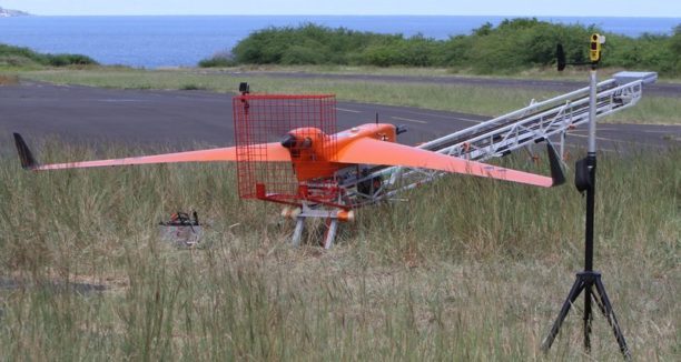
The EUREC4A project (Elucidating the role of clouds-circulation coupling in climate), co-directed by the Max Planck Institute for Biophysical Chemistry in Hamburg (Germany) and the Dynamic Meteorology Laboratory (Laboratoire de Météorologie Dynamique: LMD) in Paris, brought more than 100 scientists from Europe and the United States to work on understanding climate issues. “Understanding the effects of climate change on the tropical zone, and more particularly at the level of trade wind clouds, is a major challenge. Indeed, detecting property changes (even tiny ones) around these phenomena is essential as they illustrate the imbalances in heat exchanges that control the climate,” says a press release. More than 10 international climate laboratories with 5 oceanographic vessels, instrumented floats, land-based tools like balloons and aerosols, meteorological research aircraft, and drones – including the BOREAL long range fixed wing participated to meet the challenge.
Drones for Science
Multiple drones were used during the project, with the BOREAL flying long range (over 100 km), in coordination with manned meteorological aircraft, “to collect measurements of radiometry, aerosols, temperature, humidity and turbulence in the lower layers of the atmosphere.” Layers very close to the surface are poorly known because they are under-instrumented by scientists, even though they are precisely where the energy exchanges between the ocean and the atmosphere take place: but scientists lack data because it is too dangerous for manned aircraft to fly at an altitude of only 10 – 50 meters above the surface.
“The BOREAL is capable of taking measurements very close to the surface thanks to its on- board radar, and has been able to take trajectories less than 50m from the surface of the Atlantic Ocean for several hours at a distance of more than 100 km from the open sea,” says the announcement. The BOREAL carried custom sensors in order to meet project objectives: BOREAL can carry a payload of nearly 25 kg. BOREAL was also able to meet terrain challenges, landing on steep terrain on the east of the island.
By using multiple drones for science, the EUREC4A project also demonstrated the safe coordination of multiple aircraft: short range UAVs, long-range fixed wing UAVs, and manned aircraft, using a satellite positioning and communication system shared with all the operators on the ground.
Miriam McNabb is the Editor-in-Chief of DRONELIFE and CEO of JobForDrones, a professional drone services marketplace, and a fascinated observer of the emerging drone industry and the regulatory environment for drones. Miriam has penned over 3,000 articles focused on the commercial drone space and is an international speaker and recognized figure in the industry. Miriam has a degree from the University of Chicago and over 20 years of experience in high tech sales and marketing for new technologies.
For drone industry consulting or writing, Email Miriam.
TWITTER:@spaldingbarker
Subscribe to DroneLife here.