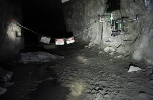
This flight took place August 28, 2020, at an Ultra-Deep Canadian Hard-Rock Mine. “Emesent’s Hovermap LiDAR payload enabled an autonomous drone flight underground,” says the release.
The missions prove the capabilities of autonomy and remote operations. The missions also make excellent business sense. Mines are particularly appropriate for drone technology: they are the dark, dirty and dangerous environs perfect for robotic missions. Mines are often in remote areas. In some cases, mines must be monitored for safety well after their production has ceased. Due to these factors, the ability to monitor a mine from anywhere in the world is a compelling business application with tremendous value to the mining industry – and many other heavy industry sectors.
In early August, Emesent conducted a remote demonstration for a South African company. In that application, operators in South Africa operated “a Hovermap-enabled drone down a tunnel in Queensland, some 11,000 kilometres away,” said the release.
Here’s how it works:
Designed to collect critical data in challenging areas, Hovermap uses LiDAR data and advanced algorithms to provide autonomous navigation even where GPS is not available. Hovermap’s Autonomy Level 2 allows the system to be operated by placing smart waypoints in a 3D map which is streamed live from the unit. Once a waypoint is set, Hovermap self-navigates to the waypoint, exploring and avoiding collisions along the way. This high level of autonomy allows the system to be operated remotely despite connectivity delays or variable internet speeds.
“We pride ourselves on the adoption of new technology such as Hovermap. We’re already using the system to map our stopes and were excited to be part of this remote operation trial. We’ve already invested in establishing a high-speed network underground to future-proof the mine and allow applications like this,” said the Mine Technical Services Manager at the Canadian mine.
“It was incredible to see a drone being flown in our underground mine all the way from Australia. This shows that remote operation is possible, and in future we’ll be able to operate the drone underground from anywhere we work – whether it be a distant location underground, from the engineering office on surface, or remote offices offsite. Many of us assumed this would still be science fiction for a while, but we’ve been proven wrong by Emesent.”
Dr Kendoul said Emesent’s dedicated technical team would continue to push the bounds of autonomous flight. “Our focus has always been on creating intelligent technology which delivers tangible benefits to the mining, construction and emergency response sectors and we don’t intend to rest on our laurels,” he said.
Miriam McNabb is the Editor-in-Chief of DRONELIFE and CEO of JobForDrones, a professional drone services marketplace, and a fascinated observer of the emerging drone industry and the regulatory environment for drones. Miriam has penned over 3,000 articles focused on the commercial drone space and is an international speaker and recognized figure in the industry. Miriam has a degree from the University of Chicago and over 20 years of experience in high tech sales and marketing for new technologies.
For drone industry consulting or writing, Email Miriam.
TWITTER:@spaldingbarker
Subscribe to DroneLife here.