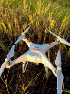
SolSpec has developed an online asset management tool that allows users to visualize and extract information specific to pipeline construction and operations.
The drone system has already mapped 3,000 miles of pipeline for several Fortune 500 oil and gas pipeline operators. The system delivers critical project data and, for one client, saved more than $10 million.
“We haven’t even scratched the surface with the information we can provide the industry,” company official Robert Blank stated in a press release. Products range from landslide prediction models for steep terrain, to various documentation options for reporting.
Blank adds:
“We value our relationships with our clients above all else. SolSpec was born out of the oil and gas world so we understand the challenges associated with multi-billion-dollar pipeline construction projects. Our clients appreciate our approach because we listen to their needs, then tell them exactly what they need to know and nothing they don’t. [They] are not necessarily looking for a pretty map of their assets. They want reliable, defensible information they can act on and archive, and they want it fast. Our software and algorithms are built from the ground up, specifically designed for this industry.”
The company plans to release a newer version of SolSpec Viewer this fall. The solution will empower users to upload and view data in a full 3D environment.
Drones have proven to be one of the primary tools for pipeline inspections as well as for other infrastructure assets.
- In 2016, Skyworks launched Blue VU, a software suite specifically designed for oil and gas companies for remote inspection of assets. The suite organizes and sorts thousands of UAV images; tracks and controls inspection workflows and supports synchronized, multimodal exploration of UAV images using 3D point clouds, 3D building models, and 2D maps.
- Last year, Canadian-based SkyX announced a plan to target the multi-billion pipeline monitoring market with drones capable of recharging themselves and, according to the firm, offering maximum range at a minimum cost.
- Silent Falcon UAS Technologies created a solar/electric, fixed wing, long-range drone system to inspect and monitor oil and gas production and distribution assets.
- General Electric is testing autonomous drones to inspect refineries, factories and railroads.
Jason is a longstanding contributor to DroneLife with an avid interest in all things tech. He focuses on anti-drone technologies and the public safety sector; police, fire, and search and rescue.
Beginning his career as a journalist in 1996, Jason has since written and edited thousands of engaging news articles, blog posts, press releases and online content.
Email Jason
TWITTER:@JasonPReagan
Subscribe to DroneLife here.