It’s an often unaddressed but tragic outcome of war: the loss of heritage buildings and sites central to the identity of a community. Now, a group of humanitarians is using drones and mapping tools from DroneDeploy to monitor and document these sites.
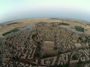
Led by humanitarian Nicholas Mellor, the founder of the mCubed Initiative of LSN Ltd., the team “is pioneering the use of agile, non-invasive approaches to documenting and monitoring endangered heritage and creating new avenues of international collaborative research, community outreach, education and advocacy.” Those agile and non-invasive approaches include the use of drones and the involvement of the local community. And in a project that started at the British Academy and brought the team to the edge of the Sahara, a group of partners successfully demonstrated the value of the technology in Djenne, Mali.
The partners – which included the Endangered Archaeology in Middle East and North Africa project (EAMENA), Oxford University; Ptolemais-Hermiou, Sohag; Documentation and Archaeological Survey Project, Helwan University; Ministry of Egyptian Antiquities; Mali Mali; and Inition – “needed an agile, cost effective means of showing that it was possible to map, model and monitor even the most isolated sites,” says Mellor – especially those at risk, “in this case by a violent insurgency,” he explains.
While heritage sites are not the primary concern of most military organizations, they are critical to the resilience of communities. This blog post from the Humanitarian Innovation Fund explains it eloquently: “Heritage is about more than artefacts, buildings and sites. It is about people’s memories and how they make sense of their surroundings and history,” says the post. “It is about the accumulated culture of communities, the ideas that bind them together and help shape their sense of identity, something that can provide resilience in the face of challenges to livelihoods or even to existence.”
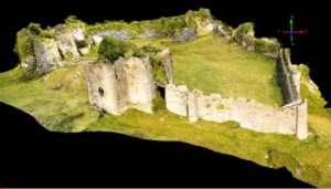
The team set out to find a viable way of documenting sites under the most challenging of circumstances. They created a prototype system of training local community activists to fly drones and create maps and models of heritage sites from aerial imagery, using the DroneDeploy mapping software. Those maps and models will be used “for conservation records, advocacy and education,” says the project blog.

“We are now seeking to create a community of heritage, technology and academic experts to work together to share best practice in conservation, advocacy and education, around the world,” says the team.
“It is hoped this pilot project will eventually be widely adopted across the region, allowing us to build a network of heritage champions and digital entrepreneurs,” says the project blog. “If we can do that, then this sort of community-based heritage stewardship will be seen as a key element in humanitarian response.”
Miriam McNabb is the Editor-in-Chief of DRONELIFE and CEO of JobForDrones, a professional drone services marketplace, and a fascinated observer of the emerging drone industry and the regulatory environment for drones. Miriam has penned over 3,000 articles focused on the commercial drone space and is an international speaker and recognized figure in the industry. Miriam has a degree from the University of Chicago and over 20 years of experience in high tech sales and marketing for new technologies.
For drone industry consulting or writing, Email Miriam.
TWITTER:@spaldingbarker
Subscribe to DroneLife here.