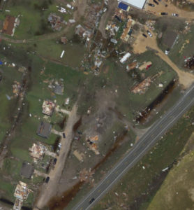
Following the flooding and damage in Houston and along the Texas Gulf Coast, Airbus has started to utilize its Airbus Aerial drone data services to help Hurricane Harvey survivors and major insurance companies connect for help.
Airbus Aerial is the commercial aerial data startup of the aerospace and defense giant based in the Netherlands. Airbus is the largest provider of satellite imagery in the world: Airbus Aerial provides aerial data and analysis to enterprise customers by combining drone data with that captured by high altitude aircraft and Airbus’ existing satellite infrastructure. The combination allows Airbus Aerial to provide analysis combining pre-event satellite data with current satellite data and low altitude images.
Airbus Aerial is making much of that data available for free to help victims, providing video, photos and other valuable data of homes and businesses that have been impacted by the hurricane to insurers. Insurers have started to use the data as a triage tool so they can prioritize where they send teams.
The ability to utilize aerial data from satellite and drones allows for unique analysis. The Airbus Aerial platform can take radar data from before the storm and overlay imagery from after – allowing insurers and others to identify changes immediately.
“Drones become most useful when you combine them in an ecosystem of tools,” says Jesse Kallman, Airbus Aerial president. “Aerial data can be incredibly powerful.”
Kallman’s team joins many in the drone industry working to provide support to hurricane response efforts. Teams of operators supporting the Red Cross and teams from the Texas Military Department to identify victims stranded in their homes rushed to Houston as soon as the flooding hit. Airbus Aerial is adding to those efforts, providing data that will help the city get back on its feet.
“If insurers can start the process of those claims faster, people can start rebuilding their lives and taking care of their families much sooner,” says Kallman. ” Aerial data is an important tool – and we can provide that next level of data.”
Miriam McNabb is the Editor-in-Chief of DRONELIFE and CEO of JobForDrones, a professional drone services marketplace, and a fascinated observer of the emerging drone industry and the regulatory environment for drones. Miriam has penned over 3,000 articles focused on the commercial drone space and is an international speaker and recognized figure in the industry. Miriam has a degree from the University of Chicago and over 20 years of experience in high tech sales and marketing for new technologies.
For drone industry consulting or writing, Email Miriam.
TWITTER:@spaldingbarker
Subscribe to DroneLife here.