On Aug. 27, the agency released a warning stating that unauthorized drone flights over hurricane-stricken areas could subject pilots to “significant fines if they interfere with emergency response operations.”
According to a Twitter posting yesterday, the FAA told a drone pilot that the agency is now “approving news gathering drone flights” but warned that “operators must coordinate with SOSC [System Operations Support Center], as outlined in the NOTAM [Notice to Airmen].”
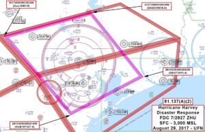
In a news update on Wednesday, the agency noted that Temporary Flight Restrictions are in place over Houston and surrounding areas including Beaumont. It’s not clear when the TFRs will be lifted but several insurance and telecom companies plan to launch flights in the coming days to assess damage.
According to a recently posted NOTAM, UAS pilots can call the FAA SOSC at 202-267-8276 to obtain authorization to fly a drone if the flight is “supporting a response, recovery or reporting-related activity,” adding that the agency is coordinating with Texas military officials to coordinate flight coverage.
Insurance giant Allstate tells Fortune that it expects to fly thousands of drone missions per week over damaged areas pending airspace clearance.
AT&T will deploy 25 drones as part of its Network Disaster Recovery Team to inspect mobile towers and other wireless infrastructure.
“Drones can take HD video and photos of a cell site, giving us a birds’ eye view of the tower. This offers high-quality visuals of equipment, components and cabling so our engineers can remotely view cell sites safely from the ground – all in real time,” a company statement read.
Virginia-based company DART LLC is working with the FAA and local Texas officials to connect drone pilots using its DroneUp mobile application to coordinate search-and-rescue operations.
The company will pair certified volunteer drone pilots with missions targeted by authorized emergency officials.
“The platform allows pilots to engage in mission communication using real-time voice, chat or text. Pilots can upload mission images or video that can be relayed to authorities and first responders directing SAR operations in the impact zones,” a DroneUp spokesperson stated. The company is maintaining a Harvey Update site.
“After seeing the devastation and loss suffered by these communities, we are eager to leverage DroneUp with the high interest of volunteer pilots to help bring assistance and relief to those who have lost so much,” DroneUp CEO Tom Walker said. “The platform was developed to provide support in the case of natural or man-made disasters, and we believe it will be extremely helpful.”
DRONELIFE readers can help Harvey’s victims out via a number of organizations.
Jason is a longstanding contributor to DroneLife with an avid interest in all things tech. He focuses on anti-drone technologies and the public safety sector; police, fire, and search and rescue.
Beginning his career as a journalist in 1996, Jason has since written and edited thousands of engaging news articles, blog posts, press releases and online content.
Email Jason
TWITTER:@JasonPReagan
Subscribe to DroneLife here.