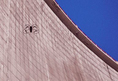
For dam infrastructure, monitoring is crucial. Operators require a simple, effective way in which to locate an area of interest on the dam’s wall and compare this to historical records—whether digital photos or annotated drawings—in order to track degradation over time.
The Tseuzier dam’s operator, Electricité de la Lienne, was interested in how inspection by drone might work and equally curious about the quality of the results. Thus senseFly sent two engineers to the site to provide a full, high-resolution inspection of the dam’s 19,000 m2 downstream face.
“Our photographic documentation today is insufficient and would definitely benefit from being enriched,” says Maurice Perraudin, the Director of Production at Energies Sion Région (the organisation tasked with producing the Sion region’s electricity).
Over the course of 50 flights the albris captured 7,000 high-resolution RGB photos
Over the course of 50 flights the albris captured 7,000 high-resolution RGB photos. Flying 3.7 m away from the face—using the drone’s Distance Lock and Cruise Control assistance settings—the albris’ collected imagery with a consistent object resolution of 0.6 mm per pixel. These images were processed with Pix4Dmapper software into several orthomosaics, supplied to Electricité de la Lienne/Energies Sion Région alongside a CAD-produced defect report.
“Taking into account the quality of the results obtained, the use of drones for the monitoring and inspecting of dams seems to have a bright future,” Perraudin suggests. “We were amazed by the quality and detail the drone achieved.”
We were amazed by the quality and detail the drone achieved.
Frank Schroth is editor in chief of DroneLife, the authoritative source for news and analysis on the drone industry: it’s people, products, trends, and events.
Email Frank
TWITTER:@fschroth
