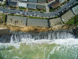
In what may be one of the most innovative combinations of emerging trends and technologies The Nature Conservancy is now crowdsourcing the monitoring of California’s coastline to drone operators.
El Niño is currently causing coastal flooding and erosion in both natural ecosystems and human communities all over California. According to The Nature Conservancy, the storms are expected to persist well into the spring and the the rate at which the coastline is changing will only increase as the storms become more frequent and more dramatic.
This makes the Nature Conservancy’s task of tracking the damage more difficult with each storm.
Fortunately, the organization has come up with a solution: The Phones and Drones Project.
Drones are becoming ever more popular and can provide an aerial view of a large area in a very short amount of time.
“We want to learn as much from this El Nino as possible and, with the help of drone operators, we can. We currently use predictive computer models to determine coastal impacts, and those will benefit from more empirical evidence that drones can provide,” said Matt Merrifield, chief technology officer with The Nature Conservancy in California. “Drone images can provide high-resolution 3D maps that will help us validate those models and determine if our predictions about coastal flooding are accurate.”
And, even if you don’t have a drone on hand, you probably have a camera in your pocket, so the Nature Conservancy is asking California residents to go out after a storm has passed and take pictures.
Higher than normal water levels (like waves overtopping dunes, water flooding salt marshes, flooded roads and other infrastructure, or breached estuary bars), coastal landslides or other big erosional events, and general property damage from floods and landslides can all provide valuable data to the Canservancy’s efforts
The Nature Conservancy can then use the data to produce an open source map of inundation areas and create spatial and temporal records of storm surge, flooding, and erosional events, which can be cross-referenced against The Conservancy’s modeled predictions. A more accurate prediction model and a subsequent counteraction plan can then be developed to prepare for future storms and damage.
“This is a perfect example of a citizen science initiative that leverages what drones do well—allowing access to perspectives from the above, with minimal cost and risk,” Eric Cheng, the former DJI Director of Aerial Imaging, told DroneLife. “Drone operators who are interested in promoting the usefulness of drones as a net-positive benefit to society should get involved!”
So if you are a California native and own a drone the Nature Conservancy would like your help. Better yet, this kind of initiative gives new drone owners the perfect subject to shoot for practicing flying skills and aerial photography skills.
For step-by-step instructions on what to do with your drone footage, go to The Nature Conservancy’s Coastal Resilience page and go to the Use Your Drone section.
Alan is serial entrepreneur, active angel investor, and a drone enthusiast. He co-founded DRONELIFE.com to address the emerging commercial market for drones and drone technology. Prior to DRONELIFE.com, Alan co-founded Where.com, ThinkingScreen Media, and Nurse.com. Recently, Alan has co-founded Crowditz.com, a leader in Equity Crowdfunding Data, Analytics, and Insights. Alan can be reached at alan(at)dronelife.com