

Sponsored by DroneDeploy —
DroneDeploy is excited to announce the release of their Elevation Toolbox and new Volume Measurement tool. This tool enables DroneDeploy users to calculate the volume of stockpiles, measure the extraction volume of a quarry or estimate the volume of a building, instantly from any device. It delivers accurate and timely volume calculations are critical across a wide range of industries including mining, construction, processing and manufacturing.
Any Map processed after 7am PT Feb 3, for users on 30 day trial, Pro or Precision will have volumetric capability
Monitoring stockpiles for one of the largest wheat processors in the Southern Hemisphere is serious business, particularly when those stockpiles are fuel sources. Not only does information about fuel usage help them make better purchasing decisions, it also helps them know when boilers are consuming fuel inefficiently and need maintenance. Since substituting drones for professional ground-based surveys they have seen their cost for volume measurements drop by half and time savings increase significantly.
Volume measurement is yet another example of the many ways that drones are helping businesses innovate. Rather than spending thousands of dollars per survey for ground-based laser measurement, you can now fly your drone over your stockyard, mine or construction site and use DroneDeploy to quickly and easily make a volume calculation. You don’t have to sacrifice accuracy either. In early tests, users reported volume measurements within 1–2% of professional survey readings.
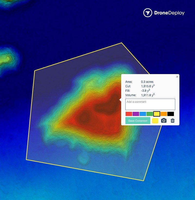
How to Measure Volume
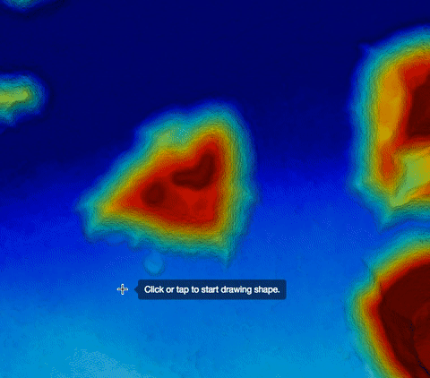
It’s insanely fast and easy to use our volume tool from any device. Simply go to your map on DroneDeploy and select the perimeter of the feature (e.g., stockpile) you want to measure. Then click the “Calculate” button to instantly compute the volume.

Behind the scenes, we create a base from the perimeter you identify. This base is intelligently created to match the surface contour of the surrounding land, meaning we’re able to compute accurate volumes even if your stockpile resides on a hill with some curvature.
We then calculate the volume between this base (representing the bottom of the stockpile or the top of a pit) and the surface of the stockpile or pit as represented by the elevation data from your map.
How to Improve Accuracy
We’ve seen volumetric measurements within 1–2% of professional ground-based laser methods, but the old adage “garbage in, garbage out” still applies. Results can vary based upon image quality and resolution, the perimeter points you select, and other factors. For tips and tricks to help you increase the accuracy of your volumetric analysis, check out our detailed support documentation, which includes a brief how-to video.
Add Volume Capabilities to a Map
The volumetric capability is currently part of all DroneDeploy’s paid plans, including the Pro plan, starting at $99 per month. Learn more about our paid subscription plans or start your free trial today.
Share Your Story
How are drone-based volume calculations bringing value to your business? We’d love to hear how you’re benefiting from the volume tool and share your story with the drone community. Email marketing@dronedeploy.com to get in touch.
What do you think? Have suggestions for improvements? We’d love to hear from you. Just email support@dronedeploy.com.


Frank Schroth is editor in chief of DroneLife, the authoritative source for news and analysis on the drone industry: it’s people, products, trends, and events.
Email Frank
TWITTER:@fschroth