from Biz Journals
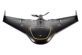
The Federal Aviation Administration (FAA) has given the Mesa County Public Works Department a license to operate a Trimble aerial imaging rover, Trimble announced Tuesday.
Trimble Navigation Ltd. (Nasdaq: TRMB), a location and positioning software company based in Sunnyvale, California, has a 125,000 square-feet office and employs about 500 employees in Westminster.
Mesa County will use the unmanned Trimble UX5 aerial imaging rover to determine volumes and compaction of its county landfill and survey and monitor infrastructure projects.
The UX5 will also be used to assist the Mesa County Sheriff’s Office or other county departments, as needed.
“With the Trimble UX5, Mesa County is one of the first to benefit from a cutting-edge solution that can change how surveyor’s collect data,” said Frank Kochevar, GPS/survey supervisor for Mesa County Public Works.
The new COA is one of many the FAA has given the Mesa County Sheriff’s office, which manages the county’s unmanned aircraft system, since 2008. A COA is required to legally operate a public unmanned aircraft in the U.S.
This is the first COA given to the Mesa County Sheriff’s office and Public Work Department together for the specific use of surveying engineering projects.
The Trimble UX5 is an unmanned fixed-wing aircraft that captures high-resolution images during flight, which is typically up to 50 minutes covering as much as 2.3 square kilometers (approximately 1 square mile) when flying 120 meters (approximately 400 feet) above the ground.
Using Trimble software, images are used to generate 2D and 3D deliverables such as orthomosaic images, 3D point clouds and contour maps.
Continue Reading at BizJournals.com…
Alan is serial entrepreneur, active angel investor, and a drone enthusiast. He co-founded DRONELIFE.com to address the emerging commercial market for drones and drone technology. Prior to DRONELIFE.com, Alan co-founded Where.com, ThinkingScreen Media, and Nurse.com. Recently, Alan has co-founded Crowditz.com, a leader in Equity Crowdfunding Data, Analytics, and Insights. Alan can be reached at alan(at)dronelife.com
