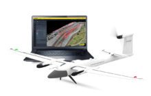
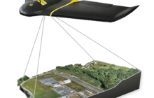
Quantum-Systems Partners with Propeller Aero: Trinity F90+ Drone and Propeller Aero’s 3D Mapping Software by DRONELIFE Staff Writer Ian M Crosby Trimble [NASDAQ:TRMB] is one of the hol... Read more
![Surveyors Wanted to Shut this Drone Photographer Down. Now, He's Fighting Back. [VIDEO]](https://dronelife.com/wp-content/uploads/2021/03/unnamed-39-e1616515014169-220x140.jpg)
Is drone mapping surveying without a license? A First Amendment lawsuit in North Carolina says surveyors cannot stop drone operators from selling photos and making maps. Hiring a surveyor i... Read more
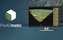
As mapping professionals are called on to map larger and larger areas around the world, photogrammetry software is evolving to meet their needs. Today, Pix4D announces PixDmatic: faster, ac... Read more

DJI has announced a raft of product news at the INTERGEO conference in Stuttgart, Germany. The updates from the drone industry’s leading manufacturer are aimed at improving the company... Read more
Drones are significant tools in pipeline surveys – get an professional surveyor’s insider look at why, and how to optimize the ROI. The following is a guest post by Dustin Price,... Read more

Not that many years ago, DJI was credited with forcing several competitors to pivot out of the drone hardware market and into commercial software. The Chinese company’s drones were too... Read more

Terra Drone Co., Ltd. headquartered in Shibuya-ku, Tokyo, have launched their image processing software “Terra Mapper” designed to assist drone surveying services. Terra Mapper i... Read more
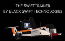
Black Swift Technologies (BST) is a specialized engineering firm based in Boulder that develops turnkey drone surveying systems. They recently conducted a successful survey of deploying a dr... Read more
Parrot‘s commercial drone company senseFly has announced that they will unveil the eBee Plus system next week at the InterGEO conference in Hamburg, Germany. The new eBee Plus system e... Read more