
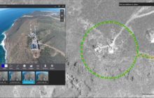
Parrot, Logiroad complete ‘impossible’ drone mapping mission over Positano By Jim Magill The Italian town of Positano, which hugs the cliffs along Italy’s scenic Amalfi Coast, is a delight f... Read more

Canada’s SimActive is a relative newcomer to the drone industry. They aren’t new to aerial mapping, however: the company was founded in 2003 by brothers Philippe and Louis Simar... Read more
February has always been great for mapping analytics firm Esri. Last February, the California-based company released Drone2Map for ArcGIS, a powerful application that captures raw, drone-bas... Read more
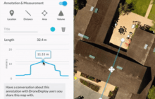
Sponsored by DroneDeploy — Easily leverage drone data in Autodesk AutoCAD, ArcGIS, and other software Elevation data is crucial to many industries. Businesses are beginning to look to drone... Read more

(Source: directionsmag.com) By 2017, the economic impact of integrating unmanned aerial systems into the U.S. economy will exceed $13.6 billion and add 70,000 new jobs, according to forec... Read more
from directionsmag.com‘s Bill McNeil The mere mention of “drones” conjures thoughts of bombs and missiles raining down on unsuspecting bad guys. However, most of today’s drones, more a... Read more